watering the lawn with the help of automatic spray systems

Smart Irrigation Starts with Design: How to Maximize Water Conservation Efforts

by Gordon Lemmel, Landscape Architect, WSB

Outdoor water consumption is a pain point for many individuals and communities, and as a landscape architect that designs both the sites and irrigation systems, I wanted to present my approach and the water savings strategies that can be used.

Limiting water usage is often much easier said than done. Properties in arid western climates for example, require some level of irrigation to keep looking nice throughout the year. They need a functional, drought-tolerant, and water-efficient landscape without compromising aesthetic values.

Planting strictly native and drought-tolerant species is an option many choose, but it’s not always practical in all situations. Using a combination of water-saving strategies is the most practical approach that landscape architects can use. We keep the big picture in mind – from initial concept to final construction documents – by focusing on strategies centered on site conditions, efficient irrigation design & technology, & efficient irrigation management.

Site Conditions

Evaluating the existing and proposed site conditions is a critical first step to water conservation on any project.

Is the site facing the hot southwest sun? Are there predominant winds that will dry plants out or carry irrigation water away? Can the soils retain water for use? Does the site slope in a way that runs water away from the plants?

Soils

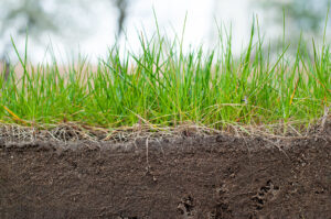
Starting from the bottom up, amending soils, or using topsoil that has compost is directly correlated to long-term water reduction. Compost is spongy and absorbent, and it facilitates the soil’s water-holding capacity and moisture dispersion.

Soil scientists from the National Sustainable Agriculture Information Service report that for every one percent of organic matter present, each cubic foot of soil can hold an extra 1.5 quarts of plant-available water (Gould, 2012). This increased water retention capability and plant-available water reduces the frequency and intensity of irrigation water.

Drainage Patterns

Understanding existing and proposed drainage patterns inform both plant selection and placement, which can be helpful for reducing water consumption. Plants that prefer wetter areas, for example, can be placed at the bottom of a slope where water collects, and vice versa.

Temperature and Solar Exposure

Both temperature and solar exposure are also important for guiding plant selection and reducing water use. Plants that are selected for projects should be either hardy or adapted to the region. These plants can survive the average high and more importantly, the average low temperatures for the region.

Light conditions (the amount and length of exposure to sun or shade) directly correlate to soil moisture. Correctly placing plants based on solar exposure helps to reduce water consumption by removing the need for supplemental watering (e.g. providing extra water to moisture-loving plants placed in drier, sunnier areas).

Efficient Irrigation Design & Technology

Irrigation efficiencies in the form of design, product selection, and technology are integral to landscape water reduction.

Design

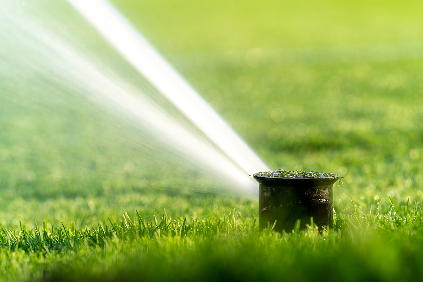
Drip irrigation is the most popular method to efficiently deliver water directly to the root of the plant and unlike broadcast irrigation methods, it reduces applying water to areas of the planting beds that do not require water – like the spaces between plants.

However, many properties have that nice green lawn that is great for recreation. While there are below ground drip irrigation options that can eliminate water waste from evaporation and wind, they are not always possible or the most cost effective. The more common above-ground systems must be designed to reduce overspray, watering of hardscape surfaces, and excessive runoff.

Products

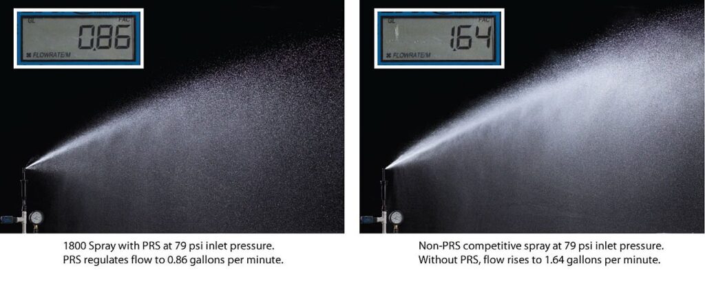
Water conservation efficiencies can also be gained through product selection, such as using pressure-regulated and matched-precipitation sprinkler heads. Pressure regulation is crucial to an irrigation system because it reduces water waste caused by high pressure operation that results in fogging or misting. Pressure regulation also ensures the nozzles run at maximum efficiency and helps support proper distribution uniformity and precipitation rates. The use of match-precipitation sprinklers helps to ensure a uniform application of water over an area and reduces excessively wet and dry areas.

Technology

The water saving technology on most modern irrigation systems uses an Environmental Protection Agency WaterSense “smart” controller that optimizes the timing, quantity, and frequency of water applied to the landscape. One important feature of “smart” controllers is seasonal adjustments. This feature allows the controller to make automatic adjustments to the daily watering schedule based on the season and geographic location.

The irrigation design may also include a variety of sensors to further fine-tune the efficiency of the system. A rain/freeze sensor shuts off the irrigation system during rain and freeze events – not only protecting the irrigation system from potential damage or safety issues, but also preventing the unnecessary application of water during (or directly after) rain events. Likewise, a soil moisture sensor will help the controller make automatic adjustments based on the moisture levels of the soil.

Flow sensors and master valves are often employed to shut off a system with “unscheduled flow events” or “high flow events.” These events are generally caused by some type of damage to the irrigation system. So, rather than letting it run until there is a noticeable issue, the sensor detects abnormal operation, shuts the system down, and can alert a user to it. Some systems can even be designed to help pinpoint where the problem is.

Efficient Irrigation Management

The final part of water conservation comes down to efficient management practices. On particularly nuanced projects, I will work with the contractors or maintenance staff on deploying efficient management strategies, such as cycle and soak irrigation. Cycle and soak programming increases infiltration and reduces runoff by breaking up water applications into shorter time periods.


This article discusses many of the methods that reduce water consumption, but there is much more!

Sites and projects greatly vary, so I always approach water conservation and reduction by being intentional and considering the what, where, and how of a project. There is no single silver bullet, but any of the methods discussed in this article are a great starting point for increasing efficiency, saving water, and saving money.

Gordon’s diverse background is beyond those of a typical landscape architect and allows him to view projects through many different “lenses.” As a former non-profit executive director, he was responsible for land management and acquisition, fundraising, volunteer recruitment and management, and working with a board of directors. This experience feeds into Gordon’s 14-year career helping organizations envision their preferred future, navigate change, lead and facilitate diverse teams, and develop relevant, inclusive, iconic, sustainable, and achievable strategies.

[email protected] | 701.214.9315

Green forest

WSB announces expansion of forestry management services, hires Emily Ball as forestry program manager

Emily Ball

Today WSB, a leading engineering and consulting firm, announced the expansion of their Forestry Management services along with the hiring of Emily Ball as forestry program manager.

The expanded service area of Forestry Management will support clients to maximize their forestry efforts by leveraging all available resources from technology and grants to industry standard best-management practices. Clients will benefit from proactive, long-term planning related to available forestry resources including forest and urban forest management planning, emerald ash borer prevention and planning, and wildfire and community forest storm mitigation. 

“There is so much potential that comes with the expansion of this service area for our firm, and most importantly, for our clients,” said Ball. “The future of our industry is about sustainability, community well-being, and being proactive in management and planning of our green infrastructure. WSB is leading the way within the industry, and I look forward to creating a significant, positive impact in my new role for clients and communities.” 

As Manager, Ball will help lead the expansion efforts. Ball has nearly 20 years of experience working as a city forester, and previously worked for the city of Lakeville to spearhead the creation of a forestry division for the city. In this role, she will support WSB clients to provide a more sustainable forestry resource plan and help them achieve their long-term goals. 

“Emily is a perfect fit for this position,” said Andi Moffatt, vice president of environmental services at WSB. “She is passionate about helping to make a difference for communities. She has great experience working within and managing various forestry projects. Beyond that, Emily has the heart and the drive to create a huge difference within the industry, and we are thrilled to have her on our team here at WSB.”

WSB supports clients in the government, commercial and energy markets with their infrastructure needs. Ball joins the firm’s environmental division. The division provides environmental compliance, natural resources, water resources, investigation and remediation, water reuse and sustainability services throughout the country.

brownfields

Brownfield Revitalization & the Infrastructure Bill

By Ryan Spencer, Director of Environmental Investigation and Remediation and Jeffery Rice, Sr Project Manager, WSB

Community leaders are always searching for ways to expand their city’s tax base, add jobs, build housing, and develop sites in ways that benefit residents and the community. Brownfields – previously developed sites that are no longer in use – are underutilized spaces that present real opportunity for economic, social, and environmental revitalization. Passed late last year, the federal infrastructure bill allocates $1.5 billion in new funding that can go toward revitalizing brownfields, providing meaningful opportunities for communities across the nation.

Whether a community is urban or rural, there is new funding available that can help revitalize and redevelop brownfields in a way that meets community needs, spurs growth, and reflects the priorities of residents.

But where to start, and how to tap into opportunities to revitalize brownfields? Here are some ways to start.

Evaluating Site Assessment & Cleanup

There are two basic categories that a brownfield falls into to qualify for grant funding. The first is an environmental assessment and the second is for site cleanup.

Communities must perform an environmental assessment (also called environmental due diligence) to determine if a site is contaminated and what kinds of contamination are present. This includes performing a Phase I Environmental Site Assessment (ESA) to identify recognized environmental conditions (RECs) and other potential hazards. If RECs are identified, then a follow-up Phase II ESA is recommended which includes advancing environmental borings and the collection of soil, soil vapor, and groundwater samples for chemical analysis. If historical buildings or other improvements are present at a site, sampling to determine the presence of asbestos, lead-based paint, or other regulated materials must be completed prior to demolition or renovation. The environmental assessment phase is useful to determine the scope/magnitude of cleanup or soil management necessary for redevelopment.

After a thorough environmental assessment is complete, the next stage uses grants to help fund site cleanup to spur redevelopment. A response action plan (RAP) is required for most cleanup grant applications. The RAP summarizes known types and locations of contamination at the site and outlines the response action methods and protocols that will be used to protect human health and the environment during redevelopment. For most projects, the goal is to manage the contamination encountered during redevelopment, not to clean up the site completely which typically is not feasible or practical.

Identifying Opportunities and Risk

Local government must be able to identify the value in brownfield assessment and clean up, obtain and maintain community buy-in for the investment, and find willing developers that are interested in working on redeveloping brownfield sites.

While some communities can be risk adverse on brownfields, the upside can be significant. Underutilized parts of a community can be revitalized to provide more low-income housing, grow the tax base, improve neighborhoods, and more.

The infrastructure bill was designed to reduce barriers to brownfield redevelopment and spur more economic and environmental development.

Collaborating with Partners

Partnerships in revitalizing brownfield sites can help position a project for success. Support from local leaders and city council, engagement with community stakeholders, and partnerships with developers interested in working on the project can all help build momentum for a project and improve its value.

Part of securing funding for brownfield projects is telling the story of how the change will revitalize and improve a community and explain how it has strong support within the community. This is especially important in the cleanup phase of the project.

How WSB Can Help

Brownfield assessment, cleanup, and revitalization involves many steps, but WSB works with communities and can help leaders navigate the process. That assistance can include environmental assessment services, assistance with grant applications and securing funding sources, community engagement, helping with project readiness, brownfield revitalization planning and design, and more.

Brownfield revitalization is a big investment that can pay off in big ways for communities, and the federal infrastructure bill provides additional funding to help jumpstart, assess, and cleanup sites across the country. The professionals at WSB are here to help you identify, apply for, and utilize money from the Infrastructure bill to help your community grow through revitalizing compromised land.

Ryan Spencer is Director of Environmental Investigation and Remediation. His expertise extends to Phase I & II Environmental Site Assessments, construction soil screening and documentation, contamination disposal and other hazardous material mitigation. He consults closely with both public organizations and private developers on their environmental needs.

[email protected] | 612.723.3644

Jeffrey has over 20 years of environmental experience including due diligence, asbestos and regulated material assessments/removal oversight and construction monitoring for response action plan/construction contingency plan implementation projects. He has provided a range of environmental services for commercial and industrial sites as well as municipal and state roadway and highway improvements projects.

[email protected] | 612.916.7067

The Importance of Monitoring and Maintaining Recreational Waters

By Tony Havranek, Director of Fisheries, WSB

Here in Minnesota, we’re proud to be the land of 10,000 lakes. We have deep ties to water – from its significant cultural importance to native tribal communities to the “Up North” summer tradition of boating, fishing, swimming, and enjoying lake life.  

But no matter if you’re in Minnesota or anywhere across the country, the health of our waters – from drinking water to recreational water – is critical to our environment, to wildlife, and to ensure that we can enjoy our time on the water today and preserve it for future generations. 

What are Recreational Waters?

People tend to have different ideas when defining recreational waters. Some instantly think of swimming, while others jump to fishing, kayaking, or boating. Recreational waters can include rivers, lakes, streams, and wetlands. 

When the government talks about waters, they designate them into categories including drinking water, agriculture, industrial, or navigational use. Within each designated use area, there are water quality standards, which can be measured numerically or narratively, that determine whether the water is fit for its designated use or impaired.

Monitoring Water Quality

Entities at all levels manage and maintain our waters, from federal and state agencies to municipal governments, to non-profit organizations, to local groups like residential lake associations. 

When evaluating a body of water’s quality for its intended use there are three main categories that can characterize the water: the water’s chemical, physical, and biological characteristics. Cities or other local entities checking water quality typically focus on measuring phosphorous, chlorophyll-a, and secchi depth since there are numerical standards developed for comparison as well as other indices which can provide additional understanding of the quality of a specific body of water with regard to these chemical characteristics.

From there, it is determined if a water body is impaired and what remedies need to be applied. 

Issues Facing Recreational Waters

There are a number of issues that can impact the health of our waters. Some are man-made, and others are caused by climate and weather changes. 

For those on the lake this summer, algae blooms are often one issue that pops up when the weather gets warm. Algae blooms occur when there is an elevated concentration of phosphorus. Too much algae can reduce water visibility and quality. Furthermore, when blue-green algae becomes too concentrated in lakes, it can be toxic to humans, dogs, and other animals.

Invasive species are also an issue for recreational waters, and are often caused by people moving plants, dirt, and/or animals into new habitats. Zebra mussels have proven to be a problem when they colonize the bottom of lakes. Their sharp shells can puncture skin and are a risk to those swimming. Phragmites australis, one of the most invasive plant species in North America, can grow tall in shallow waters, interrupting kayaking and other water activities. 

Climate change, and more extreme weather events, can also impact the health of water. High rainfall, for example, can elevate a water body to unsafe levels, flooding local communities, damaging properties, or making the water body unsafe for swimming, boating, and other activities due to contaminants in run off.

How Partnership & Collaboration Will Help Protect Recreational Waters

With so many different entities, government organizations, and nonprofits working to protect and monitor our waters, partnership is key. Greater collaboration can better protect our waters and help meet water quality goals that benefit everyone. Many grant funding opportunities exist to aid entities and partnerships interesting in improving and addressing water quality and conservation.

Only one percent of Earth’s water is fresh and available to humans, making it an incredibly precious resource. We must all work together to protect it, so we can enjoy it today and for generations to come. 

Havranek has nearly 20 years of experience in the natural resources field. Prior to his time at WSB, Tony helped develop federal policies with the U.S. Fish and Wildlife Service and worked with tribal communities throughout the Midwest on their natural resources needs. He is recognized throughout the industry for his forestry, water quality, fisheries, aquatic and terrestrial vegetation, wetlands and wildlife expertise.

[email protected] | 651.286.8473

Building Better, Safer Transportation Systems to Reduce Traffic Accidents

By Do Nam, Director of Traffic Modeling and Technology, WSB

The number of U.S. traffic deaths has been steadily increasing. According to the National Highway Traffic Safety Administration, vehicle fatality rates increased by 10.5 percent up to 42,915 last year, making it the highest number killed on U.S. roads in a single year since 2005.

The use of traffic modeling combined with cutting edge technology to mitigating risk, reducing traffic accidents, better protecting motorists and pedestrians, and analyzing ways to reverse the deadly trend of motor vehicle crashes. 

Trends, Statistics & Human Factors

Reports over the past two years have shown a significant increase in traffic fatalities across the nation. Much of this is attributed human factors like increased risk taking, which appears to have become more common in response to the pandemic.  

In 2020, when COVID-19 hit, the average vehicle miles traveled (VMT) decreased because much of the population was working from home and going out less. However, nationwide fatalities still increased from 36,355 in 2019 to 38,824 in 2020, and then up to 42,195 in 2021. With less traffic on the roads, many drivers were driving faster than the posted speed limit leading to more high-speed crashes. Furthermore, pedestrian, bicyclist, and motorcyclist fatalities were the highest they had been since 1989, 1987, and 1975 respectively.

The number of alcohol-related crashes also increased, which could be attributed to people consuming more alcohol to manage the social and economic stress brought on by the pandemic. 

Improved vehicle designs, seat belts, air bags, and new technologies like blind spot warning and automatic emergency braking systems have contributed to reduced vehicle fatalities over time, but cell phones and other distractions have caused those trends to reverse over the past decade. 

How Artificial Intelligence Improves Traffic Safety 

New emerging artificial intelligence (AI) programs assist engineers in collecting data, mapping out problematic traffic patterns, and predicting the likelihood of crashes. By using drones and traffic cameras to capture data from video, engineers use AI technology to track the movement of individual vehicles, bikes, motorcycles, and even pedestrians.

AI also allows us to better analyze traffic flow, determining work zone movements, space gaps between vehicles, and movements of heavy semi-trucks. Such advanced technology makes our analysis more informed and accurate. Through the use of data, we improve the flow of traffic, increase safety measures for drivers and construction workers, and predict where infrastructure changes are needed for more efficient and safer roads.

Do-Nam-Photo

Do has been a civil engineer in the transportation field for over 25 years. His experience includes modeling, operational analysis, design and Intelligent Transportation Systems (ITS) of large-scale transportation projects in both the United States and Qatar. Do has successfully managed over 30 major transportation and research projects utilizing traditional macroscopic travel demand forecasting modeling and state-of-the-art microscopic traffic simulation modeling techniques.

[email protected] | 763.760.8090

Chevron Tangerine Background

Zweig Group honors WSB with Marketing Excellence Awards

The Zweig Group, the leading research, publishing and advisory services resource for the Architecture, Engineering and Construction (AEC) industry, has honored WSB with three awards in marketing.

Every year, the organization offers an awards program that specifically recognizes outstanding work within the AEC industry throughout North America.

Marketing Excellence Awards

Zweig recently announced winners for the 2022 Marketing Excellence Awards for outstanding, results-driven marketing. Zweig awards the top three firms in each possible category. WSB ranked first place in two categories and second in another.

Award entries are judged by a team of marketing professionals and evaluated based upon overall creativity, messaging, results achieved by the campaign, and level of design.

New Hire Box | Recruitment / Retention Communication | First Place and People’s Choice Award

At WSB, we have six main divisions that our services fall into.  Rather than get into the weeds of the 30+ different services we offer and overwhelm our audience, we focused on our divisions to help guide the content.  Within the new hire box, there are six items that each represent a division at WSB.  To help tell the story, we created a new hire booklet that is included in each Welcome Box. The book also includes a welcome message from our CEO with tips on how to be successful at WSB, our mission and our values.  Not only do the items help us communicate our divisions, but they also help the new hire already feel part of the WSB community when they walk through the door on their first day for onboarding. 

2021 Year In Review | Internal Newsletter | First Place

Since 2009, WSB has published our annual Year in Review The goal is simple – to tell the story of WSB to our staff. In recent years, we have grown significantly both in staff size and geography.  The stories of how we’re building what’s next in infrastructure across the country are important for our staff to hear.

Every year, we explore a different way to tell WSB’s story of the last year.  We’ve told our story through our geographies, divisions, service areas, etc.  We rebranded in 2018 and since then, our five values have become a strong communications tool.  This year, we wanted to tell the WSB story through these five values to reinforce that we bring our values into our work. We are Bold, Visionary, Optimistic, Authentic and Passionate. The content was guided by these values.

Special Edition DigitalPlus | External Newsletter | Second Place

Twice a year, WSB publishes an external newsletter. For over 10 years, WSB has mailed a newsletter highlighting projects, innovations, techniques and news. We feel there is still value in a well-done printed piece.  Our WSB External newsletter typically follow a standard content format. With the introduction of DigitalPlus, we created a special edition because we’re introducing a new brand, while also straying from our typical standard format. The special edition newsletter allows us to plant a flag in the ground and tell the story of our commitment to advanced project delivery.

People’s Choice Award

WSB was awarded the People’s Choice Marketing Excellence Award at the Zweig ElevateAEC Conference in Las Vegas for the firm’s New Hire Box. The People’s Choice Marketing Excellence Award is chosen by conference attendees and is based on votes received for all first place Marketing Excellence Award winners in every category.

The complete list of Marketing Excellence Winners can be accessed here: Marketing Excellence Award (zweiggroup.com)

Gateway Center

New Mississippi Gateway Regional Park Will Connect Community and Nature

By Jeff Feulner Senior Landscape Architect, WSB

Originally published in the Minnesota Recreation & Parks Magazine Summer 2022 issue

Design work is taking place this year on an exciting project that aims to help people connect with the Mississippi River and nature.

Mississippi Gateway Regional Park, operated by Three Rivers Park District, includes 160 acres of parkland on the western shore of the Mississippi River in the City of Brooklyn Park. Coon Rapids Dam has spanned the river at the location for more than a century; in 1969, Northern States Power Co. gave the dam and 225 acres of surrounding land to what became Three Rivers Park District to establish a regional park on the Mississippi. Three Rivers operates the park on the west side of the river; Anoka County Parks and Recreation owns and operates Coon Rapids Dam Regional Park on the eastern side of the river in the City of Coon Rapids.

For five decades, the park has been a staple in the community, attracting visitors from across the Twin Cities region. Although the park is one of the most unique in the Three Rivers Park District system, it had not undergone significant investment in several years. To revitalize the park and to build better connections with the surrounding communities, in 2017 Three Rivers Park District embarked on developing a new vision for the park.

Nestled just across the road from the park is the city of Brooklyn Park’s Environmental Nature Area, a space full of opportunities to connect with nature. With the parks located adjacent to each other and only separated by West River Road, Brooklyn Park and Three Rivers Park District realized that they could provide better service to residents and park guests by working together.

The agencies developed a joint park master plan to avoid duplication and to provide a greater array of offerings for the public. Combining the park with the nature area would allow for a broader recreational experience for users. The planning process purposefully targeted equity markets that have historically been underrepresented in the visitor base for nature-based parks: minorities, non-English speaking households, new immigrants, low-income households, and people ages 45+. Throughout the master planning process, the project team engaged community residents in many ways – at community events, cultural gatherings and through user groups. The public identified features and amenities that became the basis of the vision for the park. This process made it possible for the park to truly reflect the priorities and values of the people who use it, and the resulting master plan described how together the two parks could be combined to create Mississippi Gateway Regional Park. In December 2020, Three Rivers and the City of Brooklyn Park formalized their partnership by approving a cooperative agreement to design, construct and operate Mississippi Gateway Regional Park.

“This project is the most significant capital investment in a park in the Park District’s history, and it fits perfectly with Three Rivers Park District’s vision that every person can connect with nature every day,” said Three Rivers Park District Commissioner Jennifer DeJournett, whose district includes the park. “Mississippi Gateway will welcome all individuals, whether they’re new to Minnesota or have been here for generations and will offer free and affordable programs to encourage everyone to explore the outdoors.”

With a comprehensive redesign of both areas, and a number of planned new features, the new park was born. Mississippi Gateway Regional Park will bring the vision to life: to connect the community, families, and residents to nature. To develop a strong vision that would cement this iconic park’s legacy, Three Rivers Park District and the city of Brooklyn Park consulted with WSB, a Twin-Cities headquartered design and consulting firm. Through a robust public engagement plan, master planning and design services, a vision and strategy to update the park for current and future generations to enjoy was created.

Connecting New Audiences with Nature

At the heart of this project are people. The goal is that people of all abilities and cultures have access to a fun, welcoming park where they can connect with and explore nature and the river in many ways. The location of Mississippi Gateway Regional Park provides a unique natural environment within the diverse, urban area where it lies. For children and adults alike, parks are a place to learn, exercise, grow and celebrate all Minnesota has to offer. 

A major natural feature of the park is the Mississippi River and the unique landscape and habitats that surround it. People may come to the park for a variety of reasons, but all are drawn to the beauty and power of the mighty Mississippi that forms the natural eastern border of the park.

The park means something different to every user, and it will remain a significant landmark that is safe, accessible, convenient, unique and fun for those looking to experience the beauty and wonder of nature and the Mississippi close to where they live. 

Commissioner DeJournett added, “We anticipate that the new Mississippi Gateway Regional Park will be a jewel of both the Three Rivers and Brooklyn Park systems and will be a favorite place for residents of the Twin Cities Metro Area as well as visitors from Greater Minnesota and around the country to connect with the Mighty Mississippi and enjoy the outdoors.”

What’s Coming to Mississippi Gateway Regional Park 

Meaningful updates and one-of-a-kind experiences will attract visitors and provide significant benefit to the community and region. A new Gateway Center building will offer exhibit areas with learning opportunities focused on the Mississippi River and the park, classroom areas for school groups and park programming, and a space for equipment rentals, allowing further exploration of the park through the use of snowshoes, skis or bikes.  A treetop trail, which will be an elevated walkway through the canopies of existing mature trees, will be developed near the Gateway Center. In addition, a nature-themed play tower and nature play nodes will connect to the treetop trail to create exciting play opportunities for all abilities. During the design process, staff from Three Rivers and WSB are engaging with students from Champlin-Brooklyn Park Academy for Math and Environmental Sciences to garner students’ input on the design of the nature play features. A “Mini-Mississippi” interactive water feature will provide a unique opportunity for users to access a stream channel, get their feet wet and manipulate the flow of water to further understand the dynamics of a river. These elements will provide unique perspectives, hands-on experiences, and exciting play opportunities for everyone to explore nature.

Beyond the core development area, Mississippi Gateway Regional Park will provide enhanced trails, gathering places and shelters, nature connection nodes and additional accessible fishing opportunities along the edge of the river. The western part of the park will also include a reservable shelter, playground, off-leash dog area, and an enhanced archery range. 

Even with all the planned renovations, keeping a natural feeling in the park is still an achievable goal. The focus will remain on creating accessible opportunities to connect with the natural environment. Native plantings will be included with the restoration efforts throughout the park, while other proposed elements will be nestled within the existing vegetation and terrain. 

Throughout the master planning, schematic design and design development phases of the project, the design team was careful to provide solutions that are equally engaging in all seasons of the year. The treetop trail and other trails are designed for year-round use, while cross-country ski and snowshoe trails also weave throughout the landscape.

This is an exciting project that will continue to connect the community with nature. The project is currently transitioning into the construction document phase of design, with a grand opening targeted for 2026. Mississippi Gateway Regional Park will be an inviting, welcoming and vibrant place for everyone to discover nature and the Mississippi River. 

Jeff is a landscape architect with over 21 years of professional experience. He has worked on projects of various scales and scope both in private and public sectors. He has significant experience as a project manager directing installations and overseeing project implementation. His experience has led to creative design solutions which acknowledge varied user perspectives by collaborating with private developers, landowners, and business owners, as well as municipal staff. He embraces collaboration to ultimately bring the original vision into functional reality.

[email protected]om | 612.328.6682