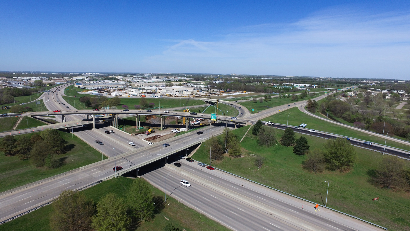
Communities rely on their streets, trails, and corridors every single day and pavement is often the most valuable and most visible asset that cities manage. However, it’s also one of the fastest to deteriorate if not maintained strategically.
As infrastructure ages and budgets tighten, more municipalities are turning to preventive approaches to pavement management as a foundational step in strengthening their overall asset portfolio. When leaders understand the true condition of their pavements and how those pavements are likely to age over time, they gain the insight needed to prioritize investments, reduce long-term costs ensuring serviceable roads for the community, and plan with confidence.
Building Smarter, Not Just Smoother
Traditional approaches often focus on fixing the worst roads first. While intuitive, this reactive approach leads to escalating costs and unpredictable spending. Modern pavement management flips that script by identifying where early, low-cost preventive treatments can extend pavement life and delay the need for costly major reconstruction.
It’s a simple truth: Protecting good roads before they fail saves communities significant money down the line.
WSB supports this shift by combining engineering expertise with modern tools to deliver clear, defensible insight into pavement condition and need.
A More Advanced, Accurate Approach
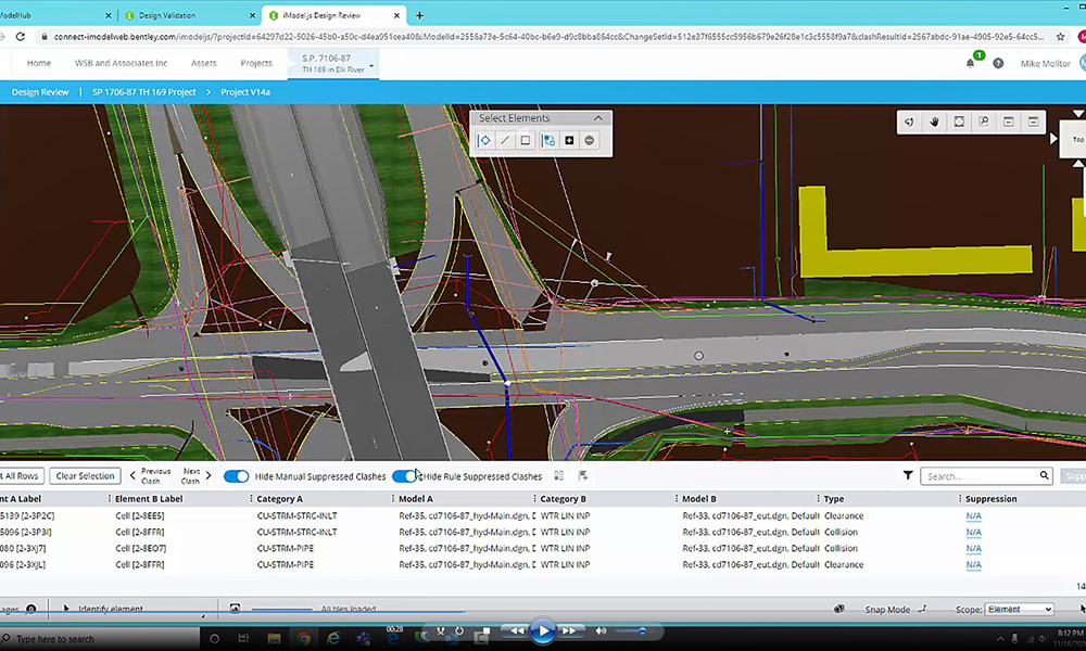
Advances in technology now allow communities to assess pavement networks with greater accuracy and consistency. WSB incorporates:
Automated condition data collection to reduce subjectivity
AI supported distress identification for improved accuracy and efficiency
Customized deterioration modeling based on local climate, traffic, and materials
GIS integrated inventory management to better inform capital planning and communication to strengthen capital planning and coordination
Integration into enterprise asset management systems (EAMS) to coordinate with other asset needs, such as underground utilities
While tools and automation are accelerating the work, engineering oversight remains essential. Our team validates results, interprets the data, develops performance models, and collaborates with clients to translate findings into practical treatment strategies.
Driving Better Decisions and Better Outcomes
With a strong pavement management program, communities can:
Improve overall network condition
Prioritize projects with confidence
Stretch limited dollars further
Reduce emergency repairs and service disruptions
Coordinate street work with underground utility needs
Build more predictable, transparent capital plans
For municipal leaders, these benefits directly support safer streets, better experiences for residents, and more resilient infrastructure.
Strengthening Your Community’s Foundation
Pavement is more than a surface; it’s the backbone of mobility, commerce, and daily life. A thoughtful, data driven pavement management strategy gives communities a powerful tool to protect that backbone and invest wisely in the future.
If your city is looking to modernize its approach, improve performance, or align limited resources with long-term goals, our team at WSB is here to help.
Shannon has spent 17 years in GIS, data analysis, asset management, and planning. She has been involved in advancing asset management at local, state, and national levels by serving on asset management committees, advisory panels, and project management teams. While working at MnDOT, Shannon directed agency-wide asset management planning including projects, research, policy, innovation, strategic planning, and implementation in collaboration with internal and external stakeholders. She is experienced in conducting risk assessments, life cycle planning strategies, developing performance measures and targets, cross-asset trade-off decision making, determining asset management system needs, investment scenario planning, climate risk modeling, and other planning efforts.
Pavement Management Expert with a Ph.D. in Civil Engineering (pavement engineering focus), bringing 5+ years of experience implementing and optimizing pavement management systems for transportation agencies. Specialized in condition data governance, PCI/ASTM compliance reviews, predictive model configuration and calibration, budget & treatment scenario modeling, and workflow optimization across preservation and rehabilitation programs. Experienced in aligning pavement management goals with municipal constraints and communicating tradeoffs and recommendations to leadership.
April 10, 2025 By Shannon McGrath, Director of Asset Management Planning & Bryan Pittman. GIS Lead, WSB
Empowering Tribal Leaders with GIS Technology
Geographic Information Systems (GIS) have revolutionized asset management across various sectors, providing intuitive, data-driven solutions to manage and optimize resources efficiently. For tribal leaders committed to enhancing their communities, embracing GIS to support tribal asset management can be transformative. This article explores the role of GIS in asset management, the benefits it offers, and how to initiate its use within tribal communities.
Understanding GIS in Asset Management
GIS integrates spatial (location-based) and traditional asset data, creating an interactive map of resources. This comprehensive approach involves collecting, storing, analyzing, and visualizing data related to infrastructure, land parcels, planning, utilities, and environmental resources. By geographically displaying asset data, GIS facilitates informed decision-making and efficient resource allocation. By leveraging geospatial technology, tribal leaders gain unique insights into asset location and other available attributes such as type, description, condition, and age, fostering a data-driven approach to capital and maintenance planning.
Benefits of GIS in Asset Management
Enhanced Decision-Making GIS empowers tribal leaders with critical data to make informed decisions. By visualizing assets and their status on maps, leaders can identify areas needing attention, prioritize investments, and plan for future developments. This data-driven approach ensures resources are allocated efficiently and effectively, leading to improved outcomes for the community.
Improved Resource Allocation One of the significant advantages of GIS is its ability to optimize resource allocation. Whether managing land use, infrastructure maintenance, or environmental conservation, GIS-based spatial analysis helps in pinpointing precisely where interventions are needed. This precision reduces waste, minimizes costs, and ensures that resources are directed where they will have the most significant impact.
Effective Monitoring and Maintenance Regular monitoring and maintenance of assets are crucial for sustainability. GIS-based asset management systems enable automated tracking and reporting, ensuring that assets are maintained in optimal condition. Tribal leaders can set up alerts for maintenance schedules, create work orders, monitor asset conditions in real-time, and efficiently manage repairs and upgrades.
Community Engagement and Transparency Transparency is vital for building trust within the community. GIS platforms and interactive web maps can be used to share information with community members, fostering engagement and collaboration. By providing access to data and maps, leaders can involve the community in decision-making processes, enhancing participation and fostering a sense of ownership.
Disaster Management and Response In the face of natural disasters, GIS proves to be a valuable resource. By mapping assets and identifying vulnerable areas, leaders can develop comprehensive emergency response plans. Flood and slope vulnerability models can be overlayed with asset locations. GIS facilitates quick response times, efficient resource deployment, and effective coordination during crises, safeguarding community well-being.
Getting Started with Managing Assets in GIS
Implementing GIS to manage assets in tribal communities requires strategic planning and investment. Here are steps to get started:
Assess Current Needs and Capabilities Begin by evaluating the current state of asset management within the community. Identify the assets that need to be managed, the data available, and the technology infrastructure in place. Understanding your starting point is crucial for a successful GIS implementation and to determine if a more robust asset management system with GIS integration is necessary.
Data Collection and Integration Accurate and comprehensive data is essential for effective GIS asset inventories. This requires collecting both spatial and non-spatial data, collaborating with stakeholders across departments to ensure completeness. Integrating historical records, real-time updates, and detailed attributes creates a unified and reliable dataset.
Training and Capacity Building Invest in training for your team to ensure they can effectively use the GIS platform and data collection tools. Providing comprehensive training programs and capacity-building initiatives will empower staff with the skills needed to leverage GIS technology. Partnering with experts like WSB for training can facilitate a smoother transition and enhance proficiency.
Developing a Data Maintenance and Update Plan Managing asset data in GIS is an ongoing process. Establish a plan for regular data updates and system maintenance to keep the platform functional and accurate. Set up protocols for data collection, monitoring, and reporting to ensure continuous improvement of the system.
Asset Management Planning Once data is available in GIS or a GIS-integrated asset management system, an asset management plan can be developed that incorporates risk, performance monitoring, financial planning, and life cycle planning. This utilizes asset location and information to create a proactive approach to managing assets over a long period of time, ensuring the right fix and the location at the right time.
WSB: Your Partner in GIS-Based Asset Management
Embarking on the journey of GIS-based asset management can be complex, but you don’t have to navigate it alone. WSB has a team of experts specializing in GIS technology and asset management solutions tailored to tribal communities. Our professionals can help you assess your current needs, implement the right GIS platform, and provide ongoing support to maintain and optimize your system.
At WSB, we understand the unique challenges and opportunities within tribal communities. Our approach is customized to ensure that GIS asset management aligns with your specific goals and enhances community well-being. We offer comprehensive training, data integration services, and continuous support to ensure your GIS system is robust and effective.
By partnering with WSB, tribal leaders can leverage the power of GIS and asset management to drive informed decision-making, improve resource allocation, and foster community engagement. Together, we can build a sustainable and prosperous future for your community.
Embrace the potential of GIS and asset management and let WSB guide you every step of the way.
Shannon has spent over a decade advancing asset management at local, state, and national levels by serving on asset management committees, advisory panels, and project management teams. While working at MnDOT, Shannon directed the agency-wide asset management planning including projects, research, policy, innovation, strategic planning, and implementation in collaboration with internal and external stakeholders.
Bryan has worked with data models and schema for roadway assets, database design and management, data manipulation and aggregation, ESRI’s Field Maps and Experience Builder Application, Lidar data, and spatial/3D analysis. He works with clients to address their GIS needs and make sure they have the tools and training needed to be successful with GIS.
By Shannon McGrath, Director of Asset Management and Jack Woolery, Asset Management Specialist, WSB July 15, 2024
Cities exploring ways to maintain and improve infrastructure sustainably cannot overlook asset management. Thorough data collection and a thoughtful asset management plan can provide the necessary recommendations needed to mitigate weather-based risk, as well as ensure communities are reaching climate goals through green infrastructure strategies.
How can asset management further sustainability and resiliency goals for your community’s infrastructure? Here are some things to consider.
Data and Technology
Good data is the key to asset management. Data collection can be done through visual field inspections or using technology such as Light Detection and Ranging (LIDAR). In visual inspections, expert(s) travel to each individual asset to collect data and provide more detailed information than could be acquired through inspecting photos and maps.
Conversely, LIDAR is a remote sensing technique that uses light to make measurements and collect geographic locations for all above-ground infrastructure. The light pulses create a three-dimensional image that models the infrastructure with useful measurement data.
Using an Asset Management System (AMS) integrated with a Geographic Information System (GIS), any data collection can be combined with information like a site’s physical condition, soil quality, traffic volumes and an asset’s vulnerability to extreme weather events like flooding for better risk-based planning and prioritization. Additionally, water and wastewater assets may implement a Supervisory Control and Data Acquisition (SCADA) system, so system monitoring is further automated which reduces the number of in-person trips required while also providing asset stakeholders or elected officials ease of access to the information they need. To further that point, an AMS paired with 3D modeling provides an easier means of communication between internal stakeholders (e.g. planning, design, construction and asset management) and external stakeholders (e.g. elected officials and the public). The combination of expert analysis and technologies provides the information necessary to optimize an asset’s longevity.
Risk Assessment and Management
Identifying risk and risk mitigation strategies greatly improves asset resilience against risks such as extreme weather events and premature deterioration. This risk assessment can be broken down in two ways – an enterprise risk assessment and an asset level risk assessment.
With an enterprise risk assessment, locations with heightened risk of extreme weather events are subjected to an enterprise assessment which is larger in scale and can cover a sizable geographic area like a whole community, region or state. For example, communities prone to flooding may have a flood vulnerability model developed as part of an enterprise risk assessment with recommendations for new projects and upgrading current assets.
On a smaller scale, an asset level risk assessment inspects an individual asset rather than a larger location. Through an asset level risk assessment, for example, a roadway is examined to identify underground utilities, asset condition and impact of failure such as impacting a critical healthcare facility or a residence. Factors such as soil type and its impact on pipe corrosion could also be considered.
Risk assessment is tailored to fit both qualitative and quantitative approaches like climate modeling for a region or coordinating with long tenured staff and agencies with institutional knowledge on what best practices have worked for a particular asset. Risk assessments and asset management plans provide ways to improve resiliency and sustainability, prioritize mitigation strategies and costs in financial planning and prevent the loss of institutional knowledge, cutting down on unnecessary work repetition.
Incentivizing and Financing
A growing trend in states like Michigan and Minnesota is the development of state government task forces and advisory councils focused on asset management. These groups incentivize owners to have asset management plans in place to improve resiliency and sustainability. By having a management plan, asset owners and communities can properly identify at-risk areas that require updating and meet evolving state and federal climate goals. With a plan in place, communities can take advantage of the substantial federal investments for sustainable infrastructure from programs like the Infrastructure and Jobs Act (IIJA) or state infrastructure grants and legislation.
For example, the IIJA has provided upwards of $7.5 billion for the purpose of updating outdated infrastructure to improve climate friendliness and the ability to withstand climate-related disasters. Without a quality asset management team and plan in place, communities could easily miss out on these opportunities.
How WSB Can Help
WSB’s multidisciplinary team includes experts in asset management who understand sustainability practices and policies, as well as how infrastructure is impacted by natural environments and climate-related issues. By staying at the forefront of techniques and technologies like the use of 3D modeling and automated data collection systems, asset stakeholders, elected officials and the public will have all the information necessary to make the most informed decisions. We work with communities to create a holistic, comprehensive asset management approach that brings real value and is customized for your community or project.
Shannon has spent over a decade advancing asset management at local, state, and national levels by serving on asset management committees, advisory panels, and project management teams. While working at MnDOT, Shannon directed the agency-wide asset management planning including projects, research, policy, innovation, strategic planning, and implementation in collaboration with internal and external stakeholders.
Jack is an Asset Management Specialist with degrees in both Geography and GIS and worked as a GIS Technician for an oil & gas consultant for two and a half years. After transitioning into survey, he came to WSB where he works on projects for civil engineering, land development, and planning by collecting field data and completing documentation via use of survey equipment and land record maps. His background in GIS and infrastructure allows him to bring a unique perspective to asset management.
As technology evolves, so does the way we harness information. Geographic Information Systems (GIS) have emerged as a transformative technology, empowering organizations with location intelligence. At WSB, GIS isn’t just about maps; it’s about turning geospatial data into a powerful asset that fuels innovation and smart decision-making for clients. The work we do with integrating GIS with other systems provides a dynamic data-driven insights and action.
Foster Data-Driven Asset Management and Community Engagement
For government and municipal clients, GIS is a cornerstone technology. It doesn’t just create maps; it’s a system of record-enabling, efficient asset management. GIS is a system of engagement and can empower greater community insight. In Duluth, Minnesota we helped implement a GIS-driven app for citizens to report issues to the city like graffiti, downed signs or potholes. Appls like this bring maps, data and people together in real time.
Drive Private Sector Solutions
For commercial clients, GIS can help mitigate risk and drive informed decisions. For example, we collaborated with an insurance data analytics provider to infuse GIS into their products allowing them to offer a more cohesive approach to analyzing risk. GIS provides geospatial data-driven insights and predictive analytics that insurance carriers use to reduce risks and improve policyholder retention. This, in turn, empowers businesses to strategize effectively, minimizing potential losses and optimizing their operations.
Enhance Safety and Prevent Damage
Energy companies leverage GIS to enhance safety and prevent damage. These technologies provide location intelligence tools that can pinpoint potential risks and vulnerabilities with infrastructure and operations. This proactive approach enables energy companies to make informed decisions that protect their assets and improve operational customer safety.
Support Multi-Dimensional Projects and the Future of Data
As project operations become more complex and interconnected via technology, so do the dimensions of data. Our GIS solutions are future-ready, supporting integrations with Building Information Modeling (BIM) for 4D and 5D projects that add time-based and cost-based elements to the geospatial data. This advanced approach enriches decision-making and creates pathways for enhanced project data delivery, from complex urban planning to construction sequencing – offering a new level of insight.
In the rapidly evolving landscape of data utilization, GIS is the compass guiding us toward smarter decisions, efficient operations and sustainable growth. We’re not just pioneers in integrating GIS across organizations; we’re partners in leveraging its power to shape the future of diverse industries. From the public sector to the private domain, GIS isn’t just about maps anymore – it’s about transforming data into a strategic advantage.
Justin is the Director of GIS Services and leads WSB’s Geographic Information Systems (GIS) group. He has over 15 years of experience managing GIS projects, staff, software development, solutions design, systems integration, and GIS implementation. Justin works closely with our clients to implement GIS-based tools and systems that meet their needs, provide maximum value, and foster engagement.
June 12, 2023 By Shannon McGrath, Director of Asset Management Planning, WSB
Infrastructure asset management is the process of operating and maintaining assets throughout their lifecycle; managing performance, value, and risk to achieve organizational objectives. Many communities face significant challenges in maintaining assets and aging infrastructure, from roads to bridges to water and sewer systems. As infrastructure ages, it becomes more expensive to maintain and repair. In some cases, it may even become necessary to replace it altogether.
Why Asset Management Matters
Without an asset management strategy in place, jurisdictions struggle to manage their assets, resulting efficiently and effectively in communities failing to utilize data to understand their inventory, maintenance needs, and replacement requirements. Asset management is crucial as it minimizes risks and expenses while maximizing resource utilization, reducing maintenance costs, enhancing infrastructure service reliability, prolonging infrastructure lifespan, and facilitating informed decision-making for infrastructure investments.
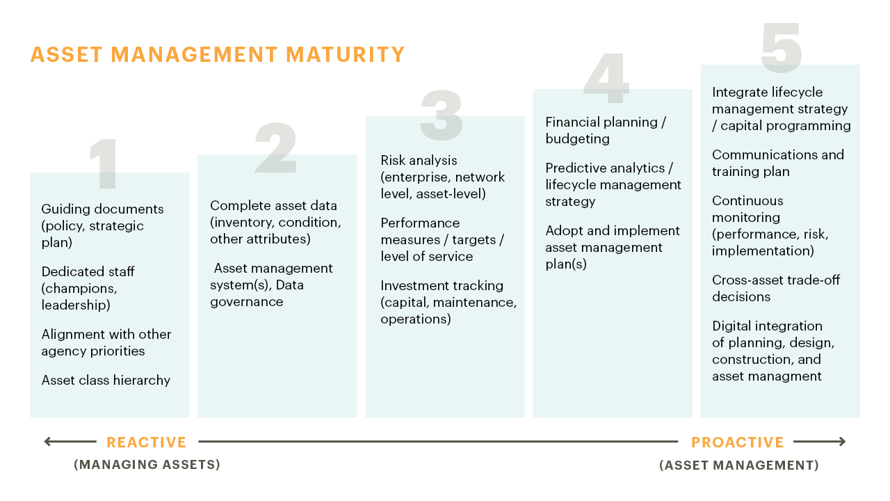
Fully Integrated & Proactive Asset Management Makes All the Difference
Proactive asset management requires jurisdictions to follow the fundamentals of asset management. We developed a maturity scale to share these fundamentals which can be used by any organization that owns, operates, and/or maintains infrastructure assets. The purpose of this scale is for an organization to identify what current efforts are in place and what steps of progression are needed to move them toward full, proactive asset management. Knowing where to start and the road ahead is crucial to ensure the efficient use of resources and enhance the overall quality of their infrastructure.
When working with organizations to create and implement asset management fundamentals, we focus on a structured and continuous approach. It begins by ensuring the right stakeholders are involved and creating a cultural shift to move from a reactive to a proactive approach. Successful asset management creates a centralized system of record, helping to reduce risk and uncertainties, allowing for a greater shared asset to data, and ensuring organizations can seamlessly collaborate across departments to improve public services. Our dedicated team takes a holistic approach with multidisciplinary experience to guide clients through asset management maturity.
Shannon has spent over a decade advancing asset management at local, state, and national levels by serving on asset management committees, advisory panels, and project management teams. While working at MnDOT, Shannon directed the agency-wide asset management planning including projects, research, policy, innovation, strategic planning, and implementation in collaboration with internal and external stakeholders.
Infrastructure assets are not something we think about often, but we rely on them in our everyday lives, so it’s important we get the most out of them. When community leaders think about how to make their cities smarter, they often don’t think broadly enough. Leaders need to expand their thinking from an operations-centric perspective to thinking about how they maintain the assets themselves.
When creating the smart city of tomorrow, there are numerous opportunities to integrate systems so that assets are better understood, better preserved, and better utilized. It means harnessing the power of digitization and predictive modeling, from major assets like roads and bridges, to smaller assets like streetlights and playground equipment.
Here are some ways that community leaders can build asset management into their smart city planning.
Ensure Smart Tools are Integrated When Managing Replacing Infrastructure
Many of our major assets are aging and no longer able to be fixed and maintained with a band-aid approach. When replacing or upgrading assets, city leaders must ensure they are using the latest software and tools that allow them to better monitor assets and predict when they will need repairs. Enterprise Asset Management Systems (EAMS) provide digital tools that allow communities to coordinate all of their asset management from a wholistic, cross-asset trade-off approach. Digital integration also ensures better communication among all city departments and leaders – from the person on the ground making repairs, to engineers, to the city official making long-term financial decisions.
Integrating digital management tools into community assets can also help cities strategically rethink capital planning over 10, 20 and 30 years. Making the digital transition in how you manage ensures that you are not just being reactive, but proactive in asset management. Moreover, it also ensures that knowledge about asset management is institutional and not lost as workers retire or move to different positions.
Understand How Smart Asset Management Mitigates Risk
Community leaders need to think about risk in two ways: the risk of an asset itself and the risk of an entire system of assets. Think about it as a pipe in a whole network of pipes. When one pipe breaks down it can impact the entire system of pipes. Better understanding when one piece of the whole will need to be updated or receive maintenance ensures a more efficient overall system, and better protects assets.
Additionally, climate change also plays a significant role in asset risk. Many systems were built decades ago, using models and assumptions that no longer work as we face more major storms and weather events. Smart city tools reduce risk and protect assets like storm water systems.
Think About Long-Term Savings
For many leaders, adopting new technologies or implementing smart city policies can feel financially overwhelming, but there are numerous long-term benefits and cost savings. Predictive modeling can better manage and preserve assets, providing savings over the long-term while reducing unexpected costs. Resources and staff time are also better utilized.
Additionally, smart asset management reduces liability, risks, and improves community safety. When managing critical but often overlooked assets like sidewalks and crosswalks, for example, there are digital trails of maintenance and asset management plans. Not only is liability reduced, but city budgets, residents, and taxpayers are better protected too.
Smart Asset Management Helps Humans Be Human
Relying on humans to know everything when it comes to asset management is unrealistic. There are so many variables and details that smart tools can predict and better manage. Rethinking asset management ensures that cities are managing all their assets in ways that are efficient, predictive, risk mitigation, and better serve residents.
Not sure where to start, or unsure of the best ways to integrate asset management into your smart city planning? WSB can help your community integrate smart technologies and tools to better manage your assets.
By Nate Osterberg, Director of Strategic Growth, WSB
Impacts on the Oil and Gas Industry
According to the Common Ground Alliance (CGA), damages to underground facilities cost $61 billion annually. To protect the public, reduce costs, and incorporate asset management, damage prevention has become a relevant conversation for stakeholders across the construction industry. Advances in technology and the Infrastructure Investment and Jobs Act (IIJA) are spurring more engagement throughout the country.
IIJA Impact
With the passage of IIJA, there is an increase in construction activity including utility, road, and renewable infrastructure. The current demand for utility locators is extraordinary and when coupled with the labor shortage and increasing demand, it is only becoming more challenging. In these circumstances, we rely on technology to guide us. To offset impacts from the labor market we incorporate digital mapping into production locating processes.
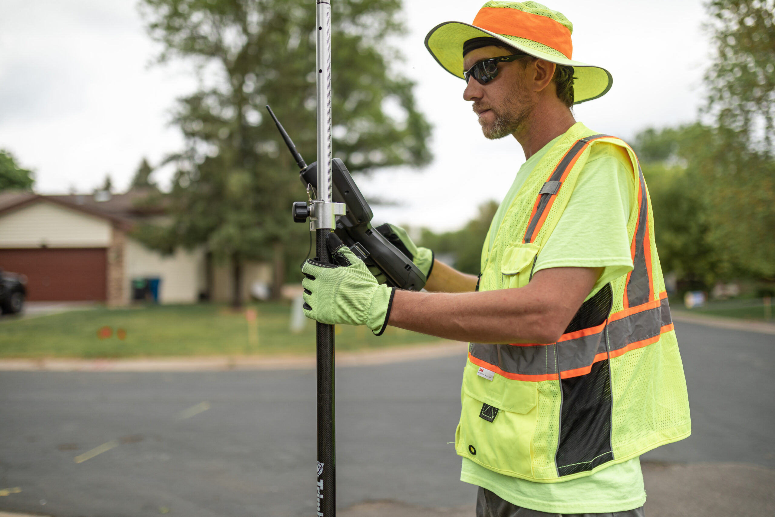
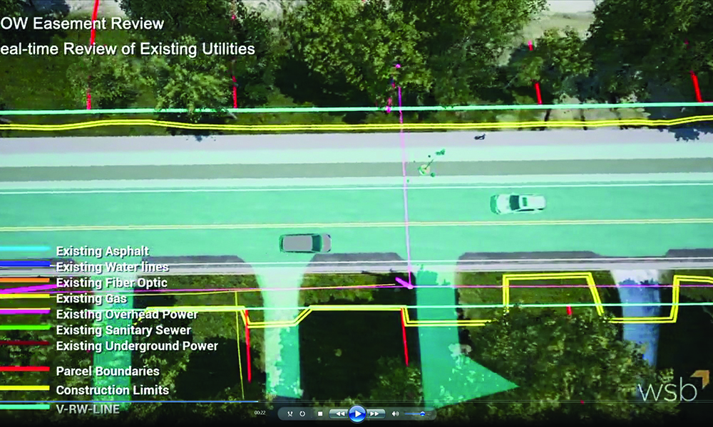
Subsurface Utility Engineering (SUE) SUE is the investigation of buried utilities that identifies conflicts and mitigates risks in the pre-engineering phase of construction. Using survey grade-accuracy with cutting-edge locating and survey equipment, capable of sub-centimeter accuracy, we identify risk and conflicts. Our team captures the location information to digitally map the facilities. When unlocatable utilities are identified, our team of damage prevention specialists approaches the challenge with different means and methods.
Cataloging for the Future
Locating the utility is the first step, but just as important is the data collection. Once a utility is located the information is documented and added to an asset management database. This process is having a major impact on the industry and is assuring accuracy for future locates. Construction plans are evaluated through a digital twin utility map, resulting in cost and time savings and enhanced design data. After decades of stagnant innovation, the industry is advancing quickly because of cutting-edge tools that allow for safer conditions and better planning.
Impact Across an Industry
With hundreds of field staff on active job sites, the collection of highly accurate location data for new and existing facilities is becoming vital to project performance. With minimal impact on budget and a streamlined mapping process, data collection efforts reduce the time it takes to provide facility owners and 811 systems with updated and accurate records.
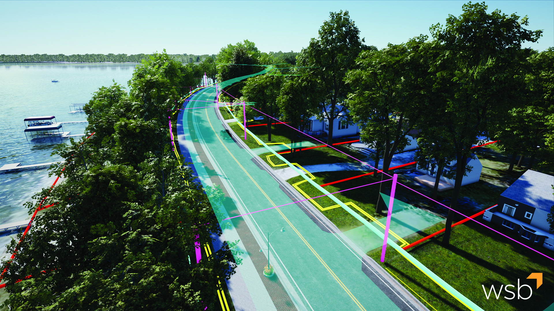
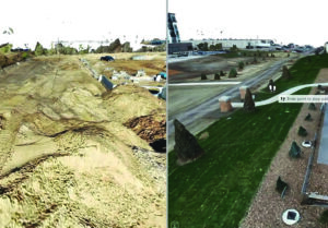
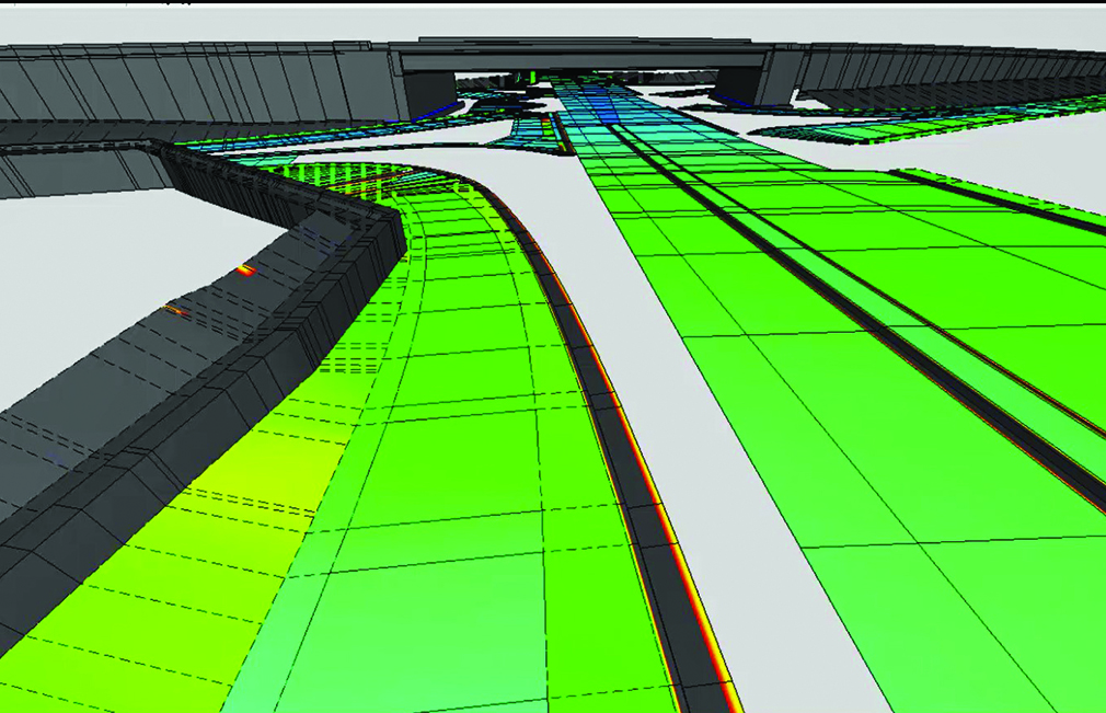
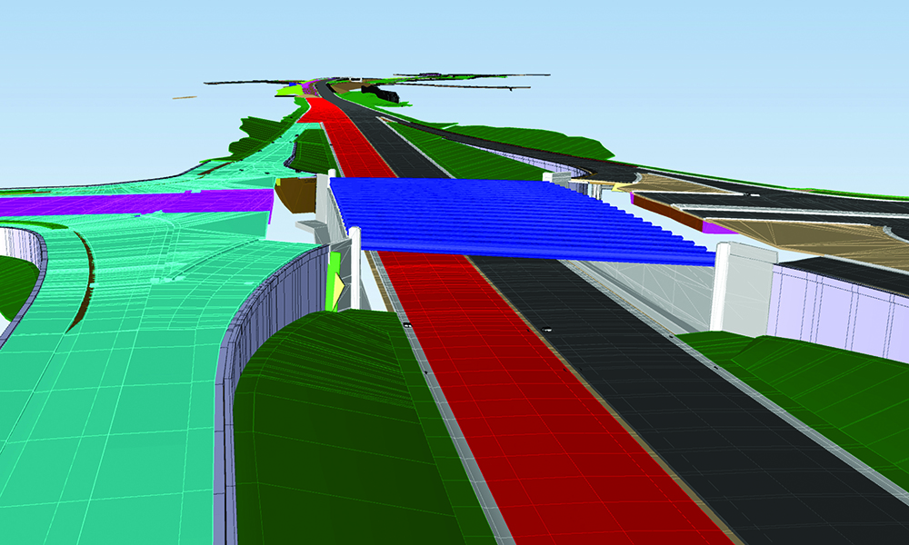
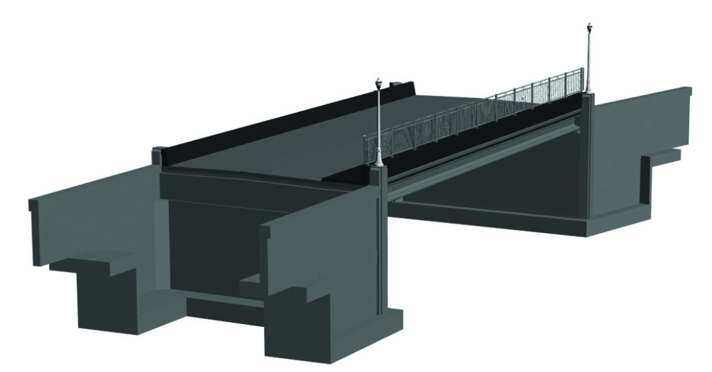
For many years, the AEC industry has been embracing advancements in the way we deliver projects. Paperless plans were the first step in this process. Fast forwarding to today, paperless plans have evolved one step further. People often refer to any digital plan set as paperless, but at WSB, we take our designs one step beyond paperless by creating 100% models. 100% models mean the entire project is created and designed in 3D.
100% models house data and design information from the entire project lifecycle, leaving owners and contractors with an accurate, detailed, data-based model to support asset management needs well into the future.
The development of DigitalPlus
WSB is committed to leading our industry in the use of cutting-edge tools to work smarter. As a firm, we’ve been at the leading edge of digital delivery efforts for many years. Our approach is unique and one that has been internationally recognized as a best practice in digital project delivery. To help tell this story, we created DigitalPlus.
DigitalPlus is the future of digital delivery. Through a combination of cutting-edge tools, expertise and a commitment to innovation, we are shaping the way our industry delivers projects. We believe in advanced project delivery, and we know how to apply the right technology and expertise to support our infrastructure needs. Through DigitalPlus, we are setting new standards, developing best practices and changing our industry’s approach to multidimensional digital design.
Why DigitalPlus
As engineers, we are motivated by the opportunities to design infrastructure projects that support our communities. The infrastructure around us has a significant impact on our daily lives. From drafting plan sets to public meetings, we live in the details and embrace the full process. We also embrace the advancements in our industry and how we can leverage technology to deliver better projects for our clients.
The benefits
Improve Quality
Sustainability
Enhanced Scheduling
Better Managed Risk
Relationship Management (Contractors | Owners)
Improve Cost
Increase Collaboration and Communication
What is DigitalPlus
A combination of expertise and cutting-edge tools.
Data Collection
Data is the foundation of any good project. We use several traditional data collection methods to gather data points that help paint a picture of the world around us. Good data is vital to the DigitalPlus process.
3D Design
Designing in 3D allows us to develop the project while providing a complete and accurate picture of the final product, significantly improving project outcomes.
4D / 5D
4D/5D modeling improves accuracy and efficiency by adding time and cost functions into design. The true power lies in the way a model can be used during preliminary design, final design and throughout construction.
Asset Management
Asset Management is the collection of an agency’s infrastructure assets and includes a plan for managing assets over the infrastructure’s lifespan. Through digital twins, assets can be managed virtually and accurately.
Utility Coordination
Digital delivery aids utility coordination by translating utility information into a 3D environment that can be compared with the design to identity and mitigate conflicts.
Visualization
Real-time 3D visualization has completely transformed site-specific review and public engagement efforts. Visualizations allow for active participation regardless of project scope and size.
Traffic Operations
Through simulation technology and trip-origin destination data, roadway designs are now guided by real-time and historical mobility movement data.
Integrated Project Delivery
A process, rather than a project that all starts with an idea. Through a combination of expertise and cutting-edge tools, land developers and owners identify opportunities and challenges before a project begins.
Machine Control Modeling
Using 3D models and GPS data, machine control modeling allows earthwork machinery to be accurately positioned. Design surfaces, grades and alignments are directly imported into construction equipment, resulting in increased accuracy and timelines.
by Shannon McGrath, Director of Asset Management Planning, WSB
The state of Minnesota’s 2022 infrastructure report card was released earlier this year by the American Society of Civil Engineers and the state of our infrastructure is not great. Within the report card, the Minnesota Department of Transportation (MnDOT) was commended for their approach to employing asset management strategies to support infrastructure needs across the state. Collectively, there are opportunities to improve infrastructure at the state and local level through the use of a comprehensive asset management program, but knowing where to start can be overwhelming.
Understanding Infrastructure Asset Management
Asset management is defined many ways. In this context, infrastructure assets should be thought of as any asset used by the public. Roads, bridges, culverts, dams, pipes, and buildings are just a few examples of public infrastructure.
From there, the approach is to develop planning and strategy to minimize total cost of ownership, increase reliability and resiliency, and meet a desired level of service.
Implementing Asset Management into Community Planning
Planning for and implementing comprehensive asset management plans and programs should be thought of as a multi-step process that includes the following:
Defining vision and objectives
Collecting and managing inventory and condition data
Conducting risk analysis
Developing performance measures and targets
Completing a performance gap analysis
Planning for life cycle management, financial, and investment strategies
Implementing technologies to meet an organization’s goal
Asset owners can start in several places, but it’s important to take a thorough, thoughtful look at all assets and plan for how to best allocate funds and time. That means taking a step back to look at the bigger picture of your desired level of service and how to achieve it both efficiently and effectively.
Scalable Solutions
Asset management is a spectrum and can be scaled to any type of asset and any size community or organization. Different communities are at different levels of maturity in planning, but it’s important to recognize a current state and where improvements can be made.
Furthermore, by facilitating discussions holistically and cross-departmentally, rather than driving asset management through a single area, the idea and importance of it can be adopted into the culture. Emerging trends like more efficient technology and tools to capture, store, and analyze data are also driving more informed decision making and helping drive better planning for communities and organizations of all sizes.
Shannon has spent over a decade advancing asset management at local, state, and national levels by serving on asset management committees, advisory panels, and project management teams. While working at MnDOT, Shannon directed the agency-wide asset management planning including projects, research, policy, innovation, strategic planning, and implementation in collaboration with internal and external stakeholders.
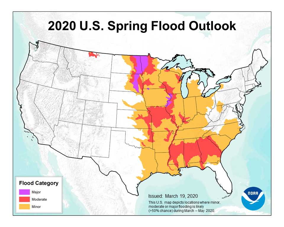
2019 marked the wettest spring on record in the U.S. and with it came extensive flooding, affecting millions of Americans. The National Weather Service just released its 2020 spring flood outlook, predicting that flooding will be above average again. Minor flooding is expected in the spring, but recent warm winters have increased flooding by saturating soils before spring rains arrive. Like 2019, this spring is forecasted to bring above normal precipitation.
Large scale
flooding damages infrastructure and displaces people from their homes. The 2019
floods caused millions of acres of farmland to go unused and transported the
farms’ fertilizer to the Gulf of Mexico, creating a massive “dead zone” where
fish cannot survive. Flooding can cause a “natural hazard cascade” where one
disaster leads to more including erosion, landslides, and chemical
contamination. The total cost of 2019 flooding is estimated to be $6.2 billion.
Our team at WSB recently developed a flood model to predict flood extent and help asset managers reduce damage to infrastructure. In general, these models can be used to assess risk for specific pieces of infrastructure, individual cities, or entire states. With this new flood model, we help asset managers determine risk by first predicting where flooding is most likely to occur. This information allows us to work with stakeholders to decide which assets are most vital. The process informs asset managers which critical assets are most likely to experience flooding and where flood risk is highest. Asset managers use limited resources to fight a seemingly unlimited amount of water. A strong understanding of risk is vital when deciding how to use limited resources for the next historic flood event. Although we cannot control the warm winters and wet springs that face us, we can control how we respond and prepare.
Nick is an environmental consultant with one year of project experience specializing in geohazard risk assessments, geomorphology, and GIS analysis. His technical skills include developing GIS models for geohazards, client consultation on how geohazards affect public and private assets, data visualization, and expertise in coastal and fluvial geomorphology. His non-technical skills include public speaking, developing client relationships, and project scoping. Most recently, Nick designed a new GIS flood risk model that estimates risk for large areas with minimal data input.