The Roundabout Craze

Andrew Plowman, Transportation Project Manager, WSB

Roundabouts have been used throughout Europe and Australia for decades but have only gained popularity in the United States in the past 20 years. There are currently more than 3,500 roundabouts in the United States. Minnesota has also joined the roundabout craze, with more than 140 roundabouts built as of 2014, and upward of 20 additional roundabouts built each year.

Some jurisdictions, such as the New York State Department of Transportation and the City of Bend, Oregon, have implemented a “roundabouts first” policy. These policies require that a roundabout be analyzed and, if feasible, should be the preferred option.

To understand why roundabouts have become so popular, it is important to understand what a roundabout is and why roundabouts perform so well compared to other intersection alternatives.

What is a roundabout?
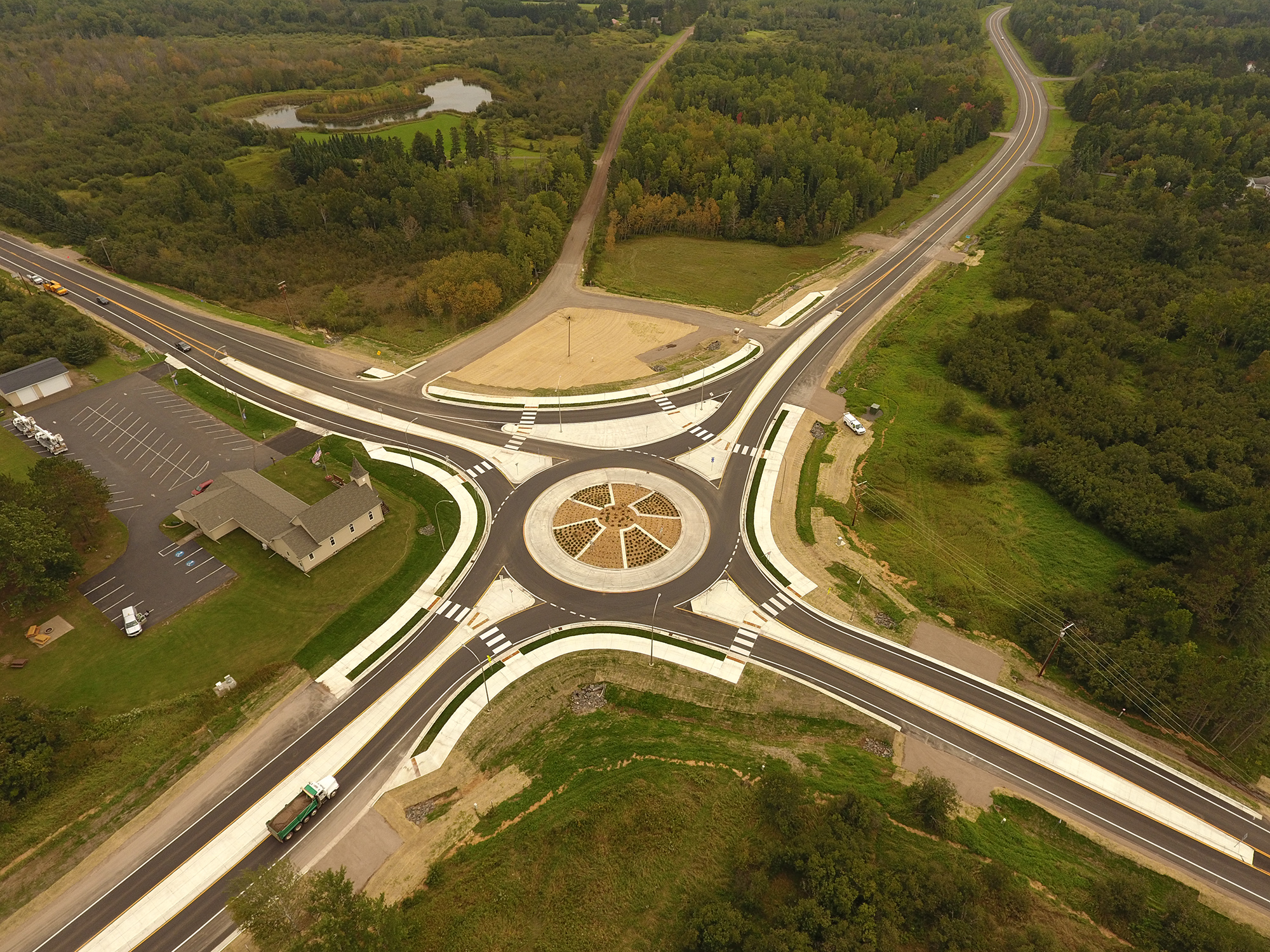
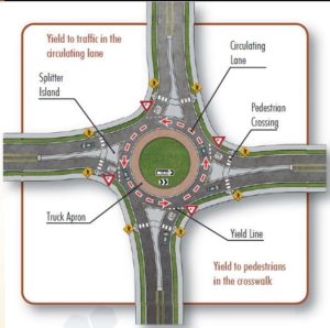
A roundabout is a type of intersection that includes a circular central island and lane(s) traveling around the central island in a counterclockwise direction. A roundabout is different from traffic circles and rotaries.

There are four main differences between rotaries/traffic circles and modern roundabouts:

Right of way

  • In a roundabout, vehicles already within the circle have the right of way.
  • In a rotary or traffic circle, entering vehicles have the right of way.

Size

  • Roundabouts are comparatively smaller (typically 80-180 feet in diameter).
  • Rotaries and traffic circles can be as big as 300-400 feet in diameter.

Changing lanes

  • Changing lanes within a roundabout is not allowed. Lane integrity must be maintained through to exit.
  • Changing lanes is allowed in rotaries and traffic circles (though sometimes this is difficult, as shown in the famous scene from National Lampoon’s European Vacation).

Deflection upon entry

  • Deflection is crucial to appropriate roundabout design, as it promotes lower speeds and encourages yielding.
  • In a rotary or traffic circle, entering traffic aims to the right of the central island, which does not promote lower speeds or yielding.

How to drive a roundabout
Roundabouts can have a variety of configurations, depending on the capacity requirements on each approach. Driving a single-lane roundabout is easier than driving a multi-lane roundabout, but the basic concept is the same. The primary concept to understand for a single-lane roundabout is this: yield to pedestrians at crosswalks and to vehicles to your left within the circulating lane.


Multi-lane roundabouts add one more step to the direction listed above: choose the appropriate lane. For example, choose the left lane if you are going left or through, and choose the right lane if you are going right or through. (Yellow line: left or through; Blue line: right or through)

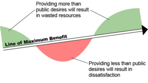
Benefits of roundabouts
Compared to standard intersections, roundabouts offer significant benefits.

  • Safety: This is one of the primary reasons roundabouts have become so popular. Research shows that roundabouts reduce fatal and injury accidents by as much as 76%, due to slower speeds and the existence of fewer conflict points.
  • Capacity and reduced delay: Due to the continuous flow of traffic, roundabouts can handle larger volumes than signalized intersections in the same amount of time. It is a common misconception that intersections are more efficient.
  • Better fuel efficiency and air quality: There is less idling by vehicles in a roundabout than in an intersection where vehicles must wait through red lights. This equates to a reduction in fuel consumption and vehicle emissions.
  • Landscaping opportunities: The central island of a roundabout is a great place to provide landscaping and can serve as a gateway to a community or district.
  • Safety for pedestrians: This is another common misconception about roundabouts. It is often thought that because a pedestrian crossing at a roundabout is uncontrolled, that it is not as safe as a signalized crossing. The figures below illustrate why the roundabout crossing is safer than crossings in standard intersections.

Roundabouts are being implemented in communities throughout Minnesota and continue to score well on many federal grant programs. We continue to stress the importance of educating drivers about how to properly navigate a roundabout, through ongoing communication with the public across multiple platforms.

Parks, Open Space, and Trail System Planning

by Candace Amberg
Feb. 6, 2015

Quality of life in any community is dependent on that community’s character, physical environment, and personal living space. These can all be improved when a community includes parks, natural open spaces, trails, and recreational opportunities.
The most successful approach to developing a park system plan – or any comprehensive planning project – is through a robust public engagement process. This will achieve the best understanding of constituent needs, resulting in local confidence that planning decisions align with and are relevant to the interests of the population being served. It is particularly important to engage the public when considering a referendum. The graphic below illustrations how a public engagement process can avoid wasted resources or community dissatisfaction.

Modern park system planning should be based on the specific needs of the community and citizens that the parks will serve. The process of developing and maintaining public space is costly and time intensive, and should be conducted through a thorough and transparent needs assessment and public process. This routinely involves hosting several input and review meetings with a wide variety of individuals, committees and stakeholders. Digital communications, social media, and other survey techniques may be effective ways to reach the right audiences.

The goal is ultimately to ensure that the findings and recommendations are a synthesis of the input from the residents, elected officials, city staff, and other community members. Following is a partial list of considerations that are typically explored when considering long-term improvements to a community’s park system.

• History of the system
• Previous planning studies and reports
• Demographics
• Recreation trends
• System-wide property and facility assessment
• Public input/needs and desires of the community
• Active/programmed recreation, as well as passive uses
• Community image, tourism, and economic development
• Trail network – internal and external connections
• Natural resource management
• Budget
• Safety and accessibility
• Flexibility of spaces to create a variety of experiences
• Operations and maintenance

Sustainable Design

By Steven Foss
Feb. 6, 2015

Our environment – natural and built – is a complex network of components, creating unique and dynamic landscapes. Sustainable design focuses on maintaining and improving environments through a collaborative approach, considering how they fit within the greater ecosystem, and employing devices that are environmentally conscious and friendly. Sustainable design strategies typically include reducing carbon footprints; improving energy efficiency; and enhancing or protecting natural habitats while still providing economic, environmental, and social benefits.


Environmental benefits of sustainable design

The major goal of sustainable design is to preserve and improve our environment while reducing our carbon footprint and minimizing the use of natural resources. When sustainable design solutions are incorporated through project development, communities and the environment benefit through one or more of the following scenarios:

  • Protecting/conserving the ecosystem
  • Improved air and water quality
  • Reduced volumes of waste
  • Conserving natural resources

Social benefits of sustainable design

Implementation of sustainable design not only provides environmental benefits to our communities, but also improves our quality of life, health, and well-being. Improving the environment and integrating sustainable practices can have the following results on individuals and communities:

  • Improved active and passive spaces for social interaction and circulation
  • Improved emotional function
  • Reduced stress
  • Improved work effectiveness
  • Stronger sense of belonging and connection to the environment

Economic benefits of sustainable design

Incorporating sustainable design, through integrated design processes and innovative use of sustainable materials and equipment, can also generate economic benefits such as:

  • Reduced infrastructure needs
  • Lower annual costs for energy, water, and maintenance/repair
  • Reduced “heat island” effect
  • Improved ability to attract new employees/residents
  • Reduced time and cost for project permitting
  • Improved use of former sites (such as brownfields)
  • Reduced construction costs through reuse of construction materials
  • Increased property values

Summary

Sustainable design transforms conventional thinking about our landscape, infrastructure and buildings. It presents significant opportunities to improve our quality of life through environmental, social and economic benefits.

The following is a list of materials and tactics that can be incorporated into sustainable design practices:

  • Preserving existing tree cover and biodiversity
  • Vegetated swales/rain gardens
  • Dry and wet ponds
  • Green roofs
  • Underground storage and permeable pavement
  • Enhanced tree plantings (Silva Cells)
  • Infiltration devices
  • Alternative energy (wind, solar, biomass, geothermal, hydroelectric)
  • Conversion of mowed/maintained turf to low-maintenance native grasses
  • Stormwater capture and reuse for irrigation
  • Use of recycled construction materials


The Alphabet Soup of Minnesota Environmental Review: EAWs, AUARs and EISs

by Andi Moffatt
Feb. 6, 2015

Acronyms

  • AUAR: Alternative Urban Areawide Review
  • EAW: Environmental Assessment Worksheet
  • EIS: Environmental Impact Statement
  • EQB: Environmental Quality Board
  • MEPA: Minnesota Environmental Policy Act
  • NEPA: National Environmental Policy Act
  • RGU: Responsible Government Unit

Introduction

The Minnesota Environmental Policy Act (MEPA) and Minnesota Rules 4410 require some projects to undergo environmental review prior to obtaining permits or approvals. The purpose of this review process is to avoid and minimize damage to environmental resources (Minnesota Rules 4410.0300). The Environmental Quality Board (EQB) promulgates rules and provides guidance to the state’s environmental review program. This article provides information about the Minnesota environmental review process, discusses some triggers for environmental review, and discusses general timelines for the process.

Background

The MEPA was enacted in 1973. It was modeled after the federal National Environmental Policy Act (NEPA), but written to specifically address other projects the state, public, and agencies deemed to need environmental review.

Three documents are the basis for Minnesota’s environmental review program:

  • Environmental Assessment Worksheet (EAW)
  • Environmental Impact Statement (EIS)
  • Alternative Urban Areawide Review (AUAR)

All three documents generally analyze similar topics for a given project, including stormwater management; wetland, habitat and fisheries; water and wastewater; traffic; air; noise; cultural resources; pollutant sources; and impact to infrastructure and the environment. The main difference between the documents is the extent and level of analysis needed.

The EAW is the heart of the state’s environmental review program. The purpose of the EAW is to determine if an EIS is needed. The EAW is intended to be a basic document, while an EIS goes into much more detailed analysis and investigation and is required if a project meets a mandatory EIS threshold or if the EAW cannot adequately gauge the possible environmental impacts of a project.

An AUAR can be thought of as a hybrid between an EAW and an EIS. While an EAW and EIS are used for specific projects (e.g., a big-box retailer proposing to develop within a city), an AUAR is used to analyze different development scenarios where a specific development is not known. Cities can use AUARs to analyze general development of a section of their city, understand possible impacts of the development, and identify specific mitigation measures. An AUAR can also be used for certain specific development plans that may trigger an EIS as an alternative to the EAW; however, there are additional review steps in these unique cases. Additionally, some types of development, such as heavy industrial development, cannot use the AUAR process.

The table below generally summarizes when to use each document.

      EAW        EIS        AUAR
  • Project with a specific development plan
  • Required by Minnesota Rules 4410
  • If petition for review is granted
  • RGU discretion
  • Project with a specific development plan
  • Required by Minnesota Rules 4410
  • EAW determines it is necessary
  • Projects with significant impact
  • Projects with undefined development plan
  • Large tract of land anticipated to develop
  • Can be used in some cases if EAW or EIS is required (check rules beforehand)


Environmental review triggers

There are many different triggers for a mandatory EAW or EIS, which depend on factors such as the location of a project, the type of project, and the city where the project is located. Common EAWs or AUARs include reviews for new residential development, construction of light industrial or commercial areas, new sanitary sewers of a specific capacity, some road projects, and projects that have large impacts to wetlands or water bodies. A full listing of the environmental review triggers can be found here.

The public can also petition to have an EAW completed for a project. In this process, a petition must be submitted to the EQB with at least 100 signatures. The EQB reviews the petition for completeness and submits it to the RGU for technical review and a final determination.

Timeline

Timelines will always depend on the specifics of an individual project or review. A general rule of thumb, however, for the time it takes to develop these documents is as follows:

  • EAW: 3-5 months
  • EIS: 1-3 years
  • AUAR: 1 year

Who completes the document?

The rules specify the RGU for each type of project. It is often the land use authority (a city or county) but could also be the Minnesota Pollution Control Agency or another agency. The project proposer is required to supply certain information to the RGU to complete the document. The RGU is responsible for making sure it is accurate and complete. We have seen this process work in one of two ways: sometimes, the RGU prepares the document with information provided from the project proposer; in other instances, the project proposer prepares the document and then the RGU reviews and finalizes it. Both ways are acceptable.

Review process

Once a document is complete, it is submitted for a 30-day public comment period and is sent to the required review agencies. After the comment period, responses will be prepared.

For an EAW, a Findings and Conclusions document is prepared for the RGU decision-making authority, such as a City Council, which is tasked with reviewing the document and preparing a Record of Decision on the Need for an EIS.

For an EIS or AUAR, a final document is prepared that includes revisions based on the comments received prior to going to the RGU decision-making authority.

What does this mean for you?

Check the required triggers for an environmental review early in the project proposal process. A project’s timeline may be impacted by required reviews. Additionally, there is a prohibition on governmental approvals and construction until the environmental review process is completed.

Complete information can be found at the Minnesota Environmental Quality Board website.

Envision: The Age of Sustainable Infrastructure is Here

By Brandon Movall
Aug 1, 2016

With the state of America’s infrastructure declining due to climate change and limited funding, today’s engineers and scientists must adopt creative and sustainable solutions. In 2011, the American Society of Civil Engineers (ASCE), the American Council of Engineering Companies (ACEC), and the American Public Works Association (APWA) came together to revolutionize the way engineers plan, design and build. The result was Envision, a holistic rating system for sustainable infrastructure.

Envision is a rating system to help project teams incorporate higher levels of sustainability at each step of a project, from assessing costs and benefits over the project lifecycle to evaluating environmental benefits and using outcome-based objectives. Envision considers social, environmental, and economic factors of projects (a process called the Triple Bottom Line), rather than only focusing on economic factors. Envision uses a scorecard of 60 credits divided into five categories that reflect all aspects of the Triple Bottom Line:

  • Quality of Life
  • Leadership
  • Resource Allocation
  • Natural World
  • Climate and Risk

By tallying the credits achieved throughout the project lifecycle, Envision is able to effectively rate proposed infrastructure options in a way that is easy to communicate to clients, consultants and owners.

While there are many sustainability rating systems out there, there are a few things that make Envision the best option:

  1. Envision rates all types of civil infrastructure, such as transportation, water, energy, information, and landscape infrastructure.
  2. Envision covers the entire life cycle of a project, from the first meeting of the project team to post-construction maintenance.
  3. Envision is free to use. Anyone can sign up for an Envision account and have access to the guidance manual and scorecard. The only costs involved are if a project is registering for awards through Envision, or if you want to get special training and become an Envision Sustainability Professional (ENV SP). These are optional and are not necessary to use the Envision system on a project.

In addition to individual users, many companies and public agencies across the United States have implemented Envision into their planning, design and construction processes. Benefits to a company or agency include discounted ENV SP certification rates, discounted project award registration rates, exclusive content from the founding organizations, and more. As part of our commitment to bettering ourselves, our clients, and our world, WSB is proud to be recently certified as an Envision qualified company.

To change the world, we must change our practices. Envision is one large step toward planning, designing and building a sustainable future. For more information about Envision in general, visit www.sustainableinfrastructure.org. For more information about Envision at WSB, please contact Katy Thompson, Brandon Movall, Stephanie Hatten, or Ann Wallenmeyer.

References:

“2013 Report Card for America’s Infrastructure.” 2013 Report Card for Americas Infrastructure. ASCE, n.d. Web. 28 July 2016.

“Envision.” Institute For Sustainable Infrastructure. N.p., n.d. Web. 28 July 2016.

Integrated Design Approach

By Robert Slipka
Feb. 6, 2015

Integrated design brings together a diverse team of design professionals on one project. Projects benefit from this approach because a wider range of experts is contributing throughout the project as a team, rather than acting independently.

Early integration is crucial to reduce the potential for expensive conflicts as design progresses or implementation begins. The integrated design approach involves all parties, including design professionals, clients/owners, permitting agencies, and others. Involvement may also include cost analysis specialists, construction managers, and contractors.

No matter what that project type, an integrated approach helps ensure a holistic outcome rather than a culmination of interdependent elements. Below are two examples of what teams could look like.

Example 1

A site development project is led by a landscape architect or civil engineer with direct integration of specialists such as environmental scientists, ecological specialists, engineers, building architects, electrical engineers, irrigation designers, and the client (including their operations and maintenance staff).

Example 2

A roadway corridor project is led by a transportation engineer and/or a planner. The team for this type of project may integrate urban designers/landscape architects, engineers, environmental scientists, right-of-way specialists, and representatives from numerous government agencies.

Design charrettes and brainstorming sessions are often utilized heavily in the beginning phases of project planning and design. This helps the team identify key goals, strategies, and desired outcomes of the project while also establishing areas of conflict or design implications. Including a diverse range of professionals means a better likelihood of achieving creative solutions that might not be explored in a conventional, non-integrated approach. As the project develops into the construction documents phase, continued collaboration is required to ensure compatibility of spatial character, uses, spaces, materials, and other factors. This approach can also identify conflicts that might not otherwise be identified until late in design or into construction, avoiding unanticipated costs or redesign.

Although an integrated approach provides better results, it is important for consultants and clients to judge how extensively integration needs to occur based on costs and benefits. Some projects are smaller in scale or fee, which can make an elaborate integrated approach difficult to justify. Clients should also be aware that the term “one-stop shop,” often utilized to describe multi-disciplinary firms, does not necessarily mean that an integrated design approach is used for projects. If it is unclear or unproven, clients should ask the consultant to describe how the various team members will be integrated throughout the design process. The ultimate goal is to achieve higher quality projects with increased cost effectiveness to clients.