McGrath will focus on development and implementation of asset management programs.
Design and consulting firm WSB announced today that Shannon McGrath joined the organization as director of asset management planning. McGrath joins the firms Minneapolis office where she will lead WSB’s development and implementation of infrastructure asset management for government and commercial clients.
McGrath has over 11 years of experience in the transportation industry. In her new role, she will develop and recommend asset management planning and strategy to minimize total cost of ownership, manage risk, increase reliability and resiliency, and meet performance standards throughout WSB divisions. McGrath’s expertise will allow her to communicate the asset management framework to key team members, field personnel and WSB clients.
“Shannon’s expertise, relationships and experience delivering strategic and innovative solutions will be key for both our staff and clients,” said WSB vice president of technology John Mackiewicz. “She will lead initiatives and deliver solutions that drive real results. We identified adding asset management planning as a key need moving forward at WSB and Shannon is the perfect person to lead this service.”
Prior to joining WSB, McGrath was the asset management planning director for the Minnesota Department of Transportation (MnDOT). In this role, she directed MnDOT’s agency-wide asset management planning including projects, research, policy, innovation, strategic planning and implementation in collaboration with internal and external stakeholders at the agency. She has also served various roles to aid in advancing asset management statewide and nationally.
“WSB is a leader in the infrastructure engineering industry and the way they deliver for their clients,” said McGrath. “I’m thrilled at the opportunity to partner with an innovative and collaborative team to advance asset management goals and objectives for clients of this fast-growing firm.”
McGrath joins the firm’s technology division but will work across the firm’s broad services areas across the United States.
By Michael Rief, Sr Vice President of Construction, WSB
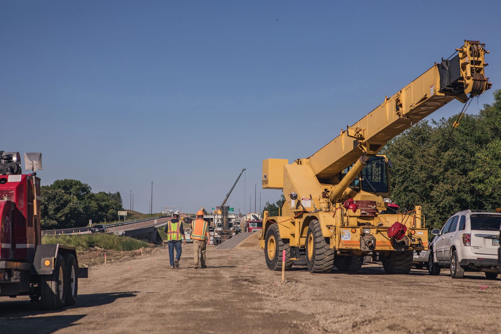
The supply chain is tightly integrated, and when one part of the supply chain faces issues, it can have a domino effect. For those working in construction, supply chain problems have caused project delays, a long wait for and lack of key materials, and frustration over the past year. Unfortunately, it shows no signs of improving in 2022.
With a shortage of labor, shipping delays, and trouble getting materials, we should prepare for our recovery to take longer than many people anticipated. As our industry continues to tackle supply chain problems, there are things construction teams can do to anticipate, innovate, and adapt to the current situation.
Be Flexible Where You Can
Flexibility is key to adapting to supply chain uncertainties. While many contracts require specific materials, if clients and contractors can build some flexibility into the contract to use alternative materials, it’s more likely that a project will be completed on time or without significant delays.
For example, some of WSB’s transportation contracts require a certain kind of seed mix, but those seed mixes may not be available for many months or at all into the foreseeable future. Allowing a substitution that is available and still meets the needs of the project allows us to finish the job sooner and more efficiently.
Consider Buying Hard to Procure Items Sooner
This applies to both construction teams and clients.
If municipalities are planning a project where they know they will need to procure certain items that may be hard to come by, doing so early and paying to store it may be more efficient in the long run and ensure your project won’t face unnecessary delays. Similarly, some contractors are procuring high-risk items and pre-purchasing material for clients, working in storage cost to help prevent delays.
Additionally, as more contractors buy materials in advance, they sometimes find they need to move materials around to different projects that face more critical needs or that have tighter timelines. Being flexible when possible can benefit both contractors and clients.
Manage Risk
With every project, it’s important to manage risk. If cities or contractors purchase hard to procure materials in advance or in bulk, and then find the value goes down in a year, they could be stuck paying to store a material that is worth less than what they paid for it. Each will have to make decisions that work best for their needs and anticipated projects.
Furthermore, building risk management into contracts can be helpful. Whether it’s procurement of materials or more flexibility on timing of projects, thoughtful contract terms can help both cities and contractors, mitigating some risk.
A great example of mitigated risk in many current construction contracts is a provision for fuel cost escalation. If the cost of fuel goes up significantly after a contract is signed, a client may pay more to cover fuel costs. Similarly, if it goes down significantly after a contract is signed, a client may recoup some of those savings. Thinking about how contracts can offer more flexibility in ways that adjust to supply chain and labor issues is something that could offer substantial benefit to all parties.
Since supply chain issues, labor shortages, shipping slowdowns, and numerous other factors are expected to continue creating challenges for the construction industry over the next year, innovation, flexibility, and adaptability can help keep projects moving forward for clients and contractors.
Mike has nearly 30 years of experience in civil engineering, with an emphasis on pavements and materials, pavement management, quality management, project management, design, risk assessment, project controls, contract administration, construction, preventive maintenance, planning, education, and technical team supervision. Mike has managed several complex, high-profile projects throughout Minnesota.
When winter storms sweep across the nation, dangerous road conditions can cause crashes, pileups, and leave commuters stranded for hours on end. How can road design play a role in making roads safer in the winter?
When roads are designed, many elements, such as drainage and flooding, are considered. Unfortunately, snowdrift prevention is often overlooked until after these disasters occur. What’s more, even long after snowstorms are over, snow can get blown back onto the roadway, requiring agencies to plow or push back the snow to clear the roadway. Significant snow accumulation, particularly on a “heavy” snow winter season, drives up maintenance cost for these agencies. Snow drift problems typically occurs on long, flat, rural stretches of highway. To create a snowdrift prevention plan, designers start by analyzing the terrain on both sides of the road. Determining how and where the snow is being picked up and drifted back onto the roadway is important in choosing which solution best suits the road.
Using that analysis, the following three options should be considered for minimizing snowdrifts and avoiding dangerous pileups:
Option 1: Wider Ditches
If there is adequate space, the best option is to have a wide ditch next to the roadway to create a “bowl” effect. These are ditches that serve as another area to capture the snow. Since roads are typically higher than the ditches, it blocks the wind and prevents snow from blowing back onto the roadway. This option requires a lot of room and typically involves additional right of way. If feasible, it is the top choice due to cost and maintenance.
Option 2: Living Snow Fence
A living snow fence consists of trees, shrubs, or hay bales along the roadway. Farmers can work with their local department of transportation to line the road with hay bales, providing a cost-effective solution to block the wind from stirring up snow from the fields and on the roadways.
Option 3: Structural Snow Fence
This option looks like a robust version of a vinyl fence used for backyards that acts as a direct wind block. These fences often require coordination with property owners because they typically are on private property and outside of public right of ways.
These above three tactics can work for many roadways, but too often they are built reactively and only after a number of crashes, pileups, and other dangers already occurred. All options require room, more often, outside of public right of way. This requires transparent and consistent coordination with nearby residents. Discussions of the benefits for each tactic is key for the residents to allow any mitigation measures in the property. Because many Midwest states see snow for one-third to one-half of the year, agencies must be more proactive, many are now incorporating these tactics into their original planning and design. The Minnesota Department of Transportation, for example, is currently working on major interstate highways in rural locations and are including analysis of the corridor as part of the project. They have a whole department dedicated to working on snowdrift prevention.
Driver safety in winter is important and proper snowdrift prevention design can go a long way to saving lives, preventing crashes, and making roads safer for all of us. WSB’s transportation team can help advise on ways to make roads safer all year round.
DJ has been a quality manager and a senior project manager in transportation, both in preliminary and final design, for over 15 years. Prior to joining WSB, DJ was a design engineer and project manager for the Minnesota Department of Transportation (MnDOT) and has managed or been part of a wide range of design-bid-build transportation projects.
Pavement management plans are crucial for cities to properly oversee their networks of pavement. These plans help decision makers maximize their limited budgets by implementing the most cost-effective maintenance solutions on every segment of their roads, parking lots, and trails. A good pavement management plan helps decide which roads should receive maintenance, when they should receive it, and what kind of maintenance would be best. Additionally, a pavement management plan must be frequently updated to accurately capture pavement conditions and needs.
It can be complicated deciding how to allocate funds in a network of roads. Fortunately, there are analytical and scientific ways to help cities decide on the best way to use their street maintenance resources. While the process of creating a pavement management plan can seem overwhelming at first, it can be broken down into six steps.
Assess Inventory
The first step in creating a pavement management plan is to take inventory of all the roads that are to be included in the plan. This usually results in an updated map of all paved streets. Roads can be broken up into numbered segments so each section of pavement can be identified. Taking inventory can also include gathering maintenance records from recent pavement maintenance.
2. Pavement Inspection
Next, gather raw data from the pavement segments in the inventory. To understand the condition of each segment, the present pavement distresses are noted. Walking the streets and visually documenting distresses is one of the most detailed methods of capturing the data. An inspector can provide notes relating to unique distresses, maintenance, and other factors that cannot be captured by simply driving the road.
3. Condition Assessment
Once the raw data is recorded, the condition of a pavement section can be quantified using a single number such as a Pavement Condition Index (PCI) or Overall Condition Index (OCI) value. These numbers are calculated from the amount, type, and severity of the distresses surveyed. Having a segment represented by a single number makes it easier to compare against other segments. An average value condition index of the entire pavement network can be calculated to set budgets and track trends in the city’s pavement.
4. Condition Forecasting
Most pavements in a specific area exhibit a common pattern as they age. A standard degradation curve or a custom curve based on historical pavement maintenance tracking can be used to predict the condition of a segment in the future. This is important because pavement degradation is not constant. Knowing when a segment is about to enter a period of steep decline in condition is useful when deciding how to allocate maintenance resources and dollars.
5. Scenario Modeling
Using the current condition information and future condition information, a model can be created to analyze the future of a pavement network. Inputs such as budget, priority segments, preferred maintenance techniques, and construction costs are all variables that can be analyzed as models are created. These factors are dependent on discussions with the city to maximize the pavement conditions and align with a preferred strategy.
6. Capital Improvement Planning
The condition analysis allows cities to create a plan that optimizes pavement condition. Results usually include a list of road maintenance and construction projects that should be completed in each of the upcoming years. Furthermore, letting a computer optimize spending removes the guess work and ensures travelers are getting access to the highest quality roads possible. City officials can use the work plan to request work from contractors and notify residents of future projects.
While the six fundamental steps of pavement management are outlined above, every city has something that makes them unique. WSB has the technology and expertise to help tailor a pavement management plan for your community. We would be happy to discuss how we can help meet your pavement needs.
Matt Indihar is a Project Manager in WSB’s Construction and Design-Build Service Group with eight years of industry experience in construction and project development. Prior to WSB, Matt worked at MnDOT’s District 3 where he served as a Graduated Engineer, Senior Engineer, and Resident Construction Engineer.
Ben Barker has been promoted to WSB’s Director of Right of Way. Barker has been with WSB for over seven years as a Right of Way Specialist. He has over 15 years of experience in real estate and 10 years in acquisitions and relocations. He has extensive experience in land rights for government entities, renewable energy companies and utility companies. He is an active member of the International Right of Way Association and serves on the Executive Board for Chapter 20.
Since joining WSB in 2014, Barker has managed a variety of complex projects, including Rice Street, I-694, Minnesota Southwest Light Rail Transit, and White Bear Ave Reconstruction. He has proven himself as an effective negotiator, strong leader, and consistently helps clients, design staff, and landowners to reach fair settlements for all parties.
In his role as Director of Right of Way, Barker will lead the Minneapolis Right of Way team and continue oversight of WSB’s Right of Way services across the United States. His focus will remain on supporting WSB’s Right of Way clients across the firm’s government, commercial and energy markets.
WSB’s Right of Way team works with closely with clients in the government, commercial and energy markets throughout the United States. The staff of real estate specialists and surveyors specialize in right-of-way issues and services including project scoping, cost estimates, relocation, eminent domain, appraisals and acquisitions.
In honor of WSB’s 26th year in business, I wanted to take a moment to reflect on our past and share the history of why our anniversary is so important.
In October 1995, the founders of WSB made the decision to leave the firm we were with after they stopped investing in technology, staff and clients. When you remove the tools that are necessary for your team and client success, the impacts are significant. For us, it was the push we needed. We came together to create a new type of firm, one that is centered on passion, optimism, and a bold vision to be the most authentic firm we can be. We have spent the last 26 years developing that mission, focusing on solid client relationships, encouraging staff to be curious and determined, and consistently pushing to be at the forefront of our industry.
When I look back, WSB has become much more than the firm we originally set out to build, and that is because of each staff member, client and partner we have worked with over the years. We believe in delivering what’s next for our clients. We live our mission and we work together during good and more challenging times to support our communities. I am grateful for how our relationships have stayed consistent and have helped us work together to navigate the past 18 challenging months.
Every year on our anniversary, we celebrate all we have accomplished, and look forward to the future. We have built a supportive culture that puts clients and people first – and that’s important to celebrate. WSB will continue to invest in our staff, our clients, and cutting-edge tools, because that is the commitment we made nearly three decades ago. I want to take today to celebrate, and I look forward to finishing 2021 strong, and welcoming new opportunities for partnership and new connections in 2022.
Q: When someone hears the term ‘brownfield’ there are a lot of visuals that come to mind, but what is an actual brownfield site?
A: That’s a good question. Brownfields are more encompassing than the traditional rundown or abandoned urban building. A brownfield is a site that has a development history which resulted in the release of contamination, often a dry cleaner, gas station, or an industrial manufacturing site come to mind. However, they can also extend to rural areas such as farmstead dumps, agricultural storage facilities, and junkyards. In general, a brownfield is any site that has documented contamination, or potential contamination, which inhibits redevelopment.
Q: Contamination in redevelopment sounds risky. What are the benefits of brownfield development?
A: There is a certain amount of risk associated with brownfield redevelopment and it varies by a community’s appetite for risk. Often, it’s a great opportunity to revitalize an area of a community that is underutilized. Those factors can strengthen the case for grant funding sources, as well.
Q: Good point. Funding is key to any project. Are there a lot of funding resources for brownfield development?
A: There are several local and federal funding sources for brownfields. Locally, funding opportunities are driven by an economic development angle and hinges on the project bringing more jobs, affordable housing, and capital investment into the area. Federally, funding sources are generally more environmentally driven and focus on cleaning up the site or a targeted area.
Q: Is brownfield redevelopment a trend right now?
A: I would not say it’s a trend right now. Rather, successful brownfield redevelopment has been occurring for many years. I see this trend continuing as developers and lenders better understand risk, funding sources are available, and undeveloped land is less common. Coming out of the pandemic, it seems that more and more brownfield redevelopment is occurring within suburban communities. There are various factors that go into both greenfield and brownfield redevelopment. It depends on what’s driving the market.
Q: What is attractive about brownfields?
A: They can drive growth and prosperity in a community. When you take an underutilized part of a community and revitalize it, it can spur more development in the area. It can also provide more housing and commercial development that leads to an increased tax base. And it’s also better for the environment – cleaning up soil or groundwater contamination is always an added benefit.
Q: What is the most important thing a community should know and how can they prepare for brownfield development?
A: It all comes back to managing risk. Understanding the site and collecting data is where I always recommend people start. Working with a trusted environmental consultant and performing the proper due diligence (e.g. Phase I Environmental Site Assessment (ESA) and Phase II ESA) allows for a deeper understanding of the site and the work that would need to be performed. There are brownfields in every community, and I think there are always benefits and opportunities associated with taking something blighted and turning it into an economic driver.
Ryan Spencer has over 13 years of experience in the environmental consulting industry servicing both public and private sector clients. He is proficient in the planning, management, and completion of environmental due diligence, remediation, and brownfield grant writing.
By Chris Petree, Director of Operations, Alison Harwood, Director of Natural Resources, and Ray Theiler, Water/Wastewater Engineer
Understanding chlorides and making responsible decisions about them is challenging at best. They serve important functions in our everyday life, but they can also create lasting damage to the world around us. Learn more about how the chlorides are used on a day-to-day basis, what the long term affects are, and what options are available to properly manage them.
What are chlorides and how do they play a role in our lives?
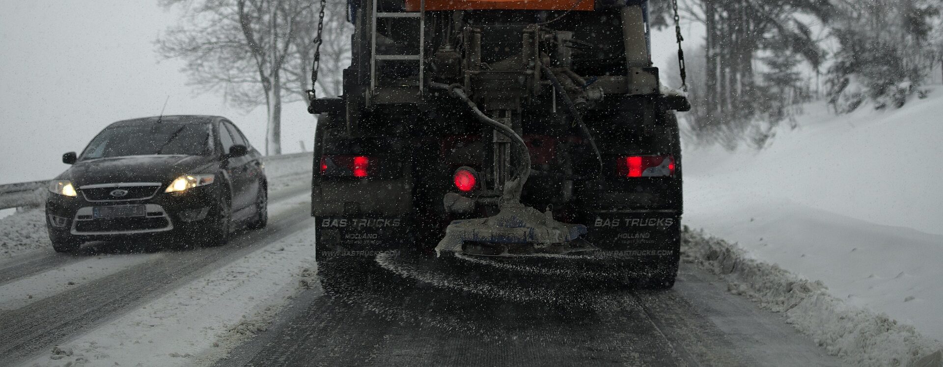
Simply put, chlorides are salt. They play a big role in Minnesota life. Primarily, they are used in our water softeners to treat the state’s notoriously hard water and for de-icing the roads during winter months.
What negative impacts does over usage of chloride have?
Overuse of chlorides can affect our communities in a variety of ways. Understanding their full impact can be nearly impossible to calculate. Below are just a few of the ways people should be aware of.
Community water supplies: Many of our communities get their water from groundwater wells. They pull water from the ground to provide a public water supply. Excessive use of chlorides leads to groundwater contamination which makes its way into lakes and rivers and ponds, ultimately infiltrating the groundwater. When the groundwater develops high chloride levels or contamination, it becomes a safety issue that communities need to address.
Plants and wildlife: When concentrations of chlorides get high enough, it begins to kill plant life and setting off a domino effect in the eco systems. High levels of chloride destroy plant roots in aquatic systems resulting in fewer plants rooted to the lakebed. The lack of supportive root systems compromises bed stabilization and leads to more opportunity for sediment to be churned up, resulting in reduced water transparency and water quality. Salt used on roads can negatively affect wildlife and local pets. These animals often eat the salt used on roadways which can lead to illness or death. Even animals who need added salt in their diet are in danger, they are attracted to roadways (i.e., deer) causing safety concerns for the animals and drivers.
Infrastructure and transportation: Regardless of the application, we know that salt can be destructive and can lead to damage. Metal is particularly susceptible to salt damage.
High levels of chlorides on the streets have historically had a negative affect on vehicles. The salt on the roads builds up on the vehicles leading to premature rusting.
Pumping water with high chloride levels through pipes can lead to corrosion within water distribution systems, which in turn leads to issues with lead and copper in our water system.
The chlorides in the water cause premature degradation and failures of storm sewer systems, specifically in catch basins and manholes.
What are the benefits of reducing chloride usage?
The benefits of reducing chlorides are a long list that includes protecting the environment, the health of the community, and local infrastructure. However, often cost is the factor that really creates urgency around reducing chlorides.
Introducing the chlorides into the environment will ultimately require repair and rehab of groundwater systems, storm water systems, water infrastructure, wetlands, etc. All these systems have costs associated with them.
Acquiring the salt is another expense. Whether a small city, county, or state, the budget needed for de-icing is huge. Salt and de-icing chemicals are not produced locally. They can only be delivered by truck, train, or barge from the South. Taxpayer dollars are the how this transportation is funded, reducing chlorides frees up tax dollars to support other needs.
How to do you continue to maintain safe roadways in the winter, while meeting environmental regulations?
Technology and training are key.
It used to be that a salt truck was sent out with only a lever and a couple of dials for the operator to control salt usage. The technology and equipment currently available allows operators to apply the exact amounts of de-icing chemical needed based on precipitation type, air temperatures, and pavement temperatures. It is critical these staff are trained to use the equipment properly. Equipment and training will require an upfront investment but will ultimately save significant amounts of money on resources and damage repair done in the long run.
Some communities are exploring alternative de-icing chemicals beyond chloride. For example, you can mix in beet juice, molasses, sand, etc. There are many alternatives and mixtures that are less harsh on the environment, more cost effective and benefit communities in the long term.
How can communities help reduce chloride usage overall?
Make sure water softeners are functioning efficiently or upgrade to a higher efficiency model.
Explore those alternatives to road salt.
Educate: There are resources and trainings available.
MPCA Smart Salt Training: Educate businesses, property managers and residents. Its important communities take an active role in chloride reduction.
Involvement: Get communities involved by including information in community newsletters.
WSB can evaluate chloride usage and make recommendations for how to move forward. Our staff have the experience and knowledge, from years and years working at public agencies, that we can provide operational assistance and assessments when it comes to communities and planning.
Wildfires are dominating headlines this summer as cities across the United States are dealing with the dangerous air conditions created by the fires in Canada. Wildfires can be incredibly scary, ushering in unwanted destruction and loss of property, but it can also be a tool for rebirth and habitat restoration.
As an ecologist, I have used controlled fire as a tool. Taking a long view of plants and wildlife, many species rely on a natural cycle of disruption that includes fire, wind, animals and more. The Jack Pine, for example, requires fire to help open its cone and release seeds. Many invasive species don’t require cycles of disruption, on the other hand, and thrive among human development.
What are the Risks that Wildfire Bring?
The clearest risk with any uncontrolled fire is destruction of life and property. Wildfires are incredibly dangerous, and this summer’s hot, dry weather helped exacerbate fires in the north. Furthermore, as climate change brings more extreme weather conditions, the carbon released from large wildfires drives further warming, feeding the cycle for more extreme weather events.
Poor forest management and extreme weather can also cause fires to burn more intensely. Too much fuel load – material in a given area that burns and can dramatically increase the intensity of a fire –means that a fire may burn faster and hotter. Intense wildfires can destroy soil to the point it is hydrophobic, repelling water instead of absorbing it. It can also destroy good bacteria and fungi in topsoil. The destruction of soil from extreme wildfires can make it more difficult for new plants to grow, cause soil erosion that pollutes streams and waterways, increase the risk of flash flooding and harm local ecosystems.
As fire crews work to fight wildfires, that can also bring some environmental risk. The flame retardant used to control the spread of fires can be toxic to certain plants and animals. And when fire crews travel from one part of the country to another to fight large wildfires, they can unintentionally introduce invasive species to new regions.
What are the Environmental Benefits?
When we read about wildfires in the news, the stories are often focused on destruction, but fire can bring environmental and ecological benefits too. Because humans have disrupted many of the natural fire cycles, burning can help reset plant species. Plants are an essential building block to ecosystems, and new plant growth can help reattract or grow the population of numerous native wildlife species. Moose, bears and deer are some of the species that can be positively impacted by regeneration after fires.
Better Planning for Fires and Other Natural Disasters.
While proper forest management and use of controlled fire helps mitigate the risk of destructive wildfires, climate change and human activity means wildfires, unfortunately could become more commonplace in certain parts of the world. Planning for and building defensible space and structures reduces risk from wildfires. Working with municipalities at WSB, we often talk about planning for flooding, erosion, hurricanes and other extreme weather events to protect infrastructure, people and native wildlife.
For communities, especially those that face a greater risk of wildfire due to climate change and other factors, assessing the threat of fire and integrating defensible space and structures into planning is critical. I expect that to become a more prevalent consideration as part of innovative municipal planning in future decades.
Havranek has nearly 20 years of experience in the natural resources field. Prior to his time at WSB, Tony helped develop federal policies with the U.S. Fish and Wildlife Service and worked with tribal communities throughout the Midwest on their natural resources needs. He is recognized throughout the industry for his forestry, water quality, fisheries, aquatic and terrestrial vegetation, wetlands and wildlife expertise.
Design and consulting firm WSB announced today the promotion of Jim Mill to director of civil site development. In his new role, Jim will lead operations and oversee business development efforts for the firm’s development work throughout Colorado and the western U.S.
Jim joined WSB in 2018 after 15 years of running his own business and has been instrumental in the firm’s growth in Colorado. His office, based in Denver, CO, currently has staff supporting work in land development, water resources, traffic, survey, and environmental compliance.
“Jim has the ability to take an idea and make it a reality,” said Monica Heil, WSB’s vice president of municipal services. “Our clients continually leverage Jim for his skills and abilities in design, master project coordination and value engineering. He has a passion for building the correct teams to support our clients and deliver the best value, budget, and timeline for all his projects.”
Jim has over 35 years of experience in development. Prior to his time at WSB, he was president of Legacy Engineering, Inc. He started his career as an Engineer in Training (EIT) with a local Denver engineering firm.
“Over the last three and a half years, WSB has been an exceptional place to exercise and grow my skills in business while establishing a strong foundation in Colorado,” said Jim. “I am excited to take on additional responsibilities and build off of this foundation to expand in all facets of our business.”
Beyond his responsibilities in development, Jim will help lead and mentor staff throughout the region from the Denver office.