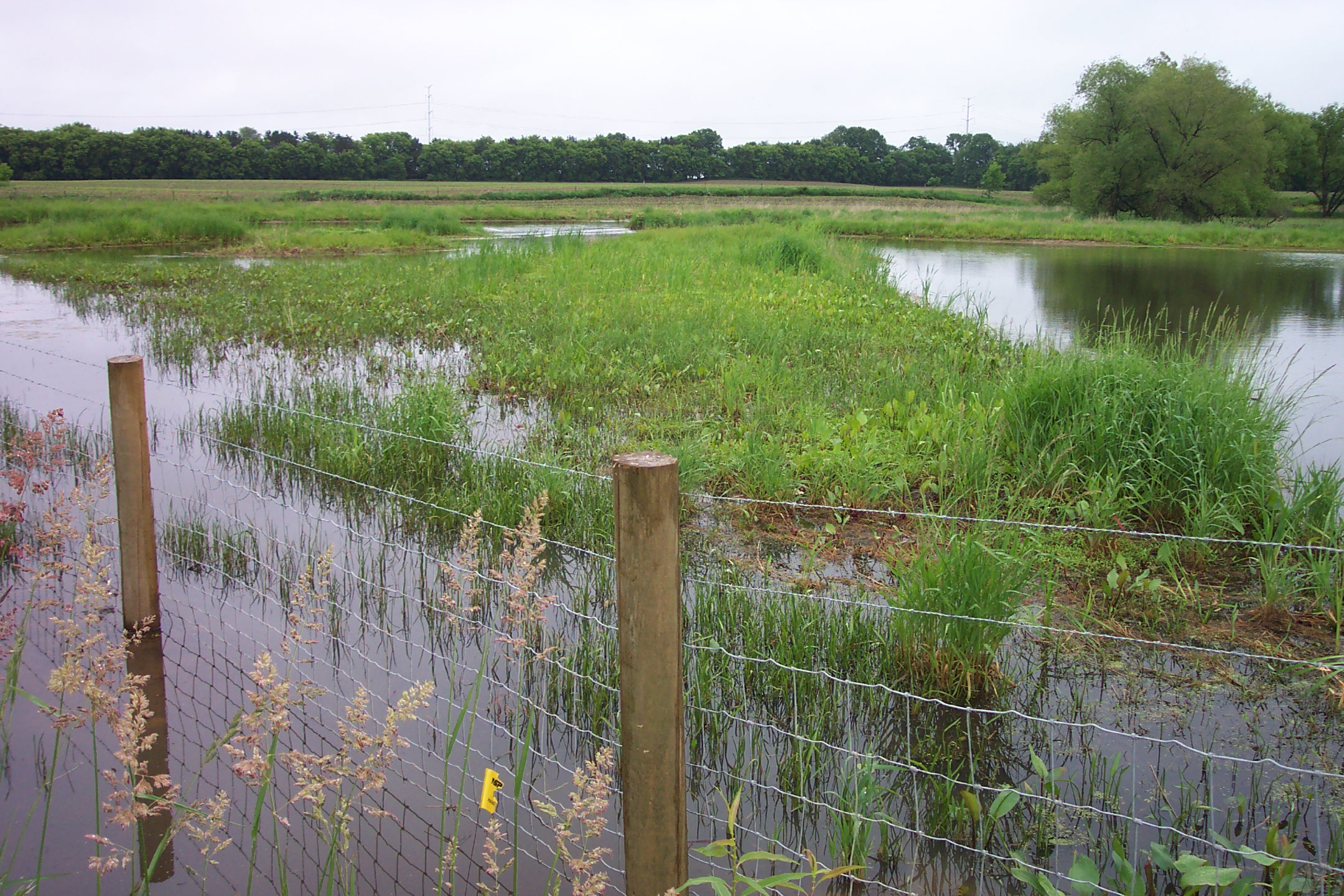
The Minnesota Department of Natural Resources (DNR), in coordination with local watershed districts, has developed updated draft Federal Emergency Management Agency (FEMA) flood risk maps and hydrologic and hydraulic analysis. The affected area includes the floodplains in the hydrologic unit code 8 (HUC8) subbasin. HUC8 includes portions of Ramsey, Washington, Anoka, and Hennepin Counties.
The updated hydrologic and hydraulic analysis is based on National Oceanic and Atmospheric Administration (NOAA) Atlas 14 precipitation events across the United States. The draft flood hazard maps may expand existing FEMA regulated floodplains within the Twin Cities metro due to the higher precipitation depth and frequency. The FEMA map updates will likely take effect in 2023. This is the first step in the process to develop updated FEMA Flood Insurance Rate Maps.
It is important that city officials pay close attention to these updates. The draft FEMA floodplain boundaries may increase with this analysis, which may reduce developable area in a municipality, increase the number of properties that are required to purchase flood insurance, and require property owners to change the type of flood insurance they possess. Additionally, the DNR is requiring that each community update their ordinance to require mitigation for fill in the modeled storage areas upstream of FEMA floodplains.
Currently, the maps are for city officials only. City staff should cultivate a strong understanding of the implications now, before the maps become open for public comment. During the next month, there will be opportunities for city staff to connect with the DNR staff, review floodplain limits, and understand the implications on developable area and properties that will require flood insurance within the community.
WSB can help navigate this process and facilitate meetings with DNR Floodplain Staff. City officials are encouraged to reach out to Earth Evans, WSB’s Director of Water Resources with questions.
Earth has 20 years of experience as a project engineer and project manager on technically diverse projects in water resources. She is a technical resource in hydrologic and hydraulic modeling, flood damage reduction and floodplain modeling, water quality modeling and evaluation of best management practices, permitting, and hydraulic design. She has has worked extensively with MnDOT and state aid requirements and coordinated with local, regional, and state permitting agencies.
By Mark Erichson, Pete Willenbring, Kendra Fallon and Ray Theiler, WSB
About 10 years ago, the City of Hugo was looking for feasible options to reduce the amount of potable water used to irrigate green spaces within the city. At that time, approximately one-half of the water the city pumped from its municipal wells was used for irrigation. The city was also facing the need to add wells, water towers, and treatment to provide enough capacity for this use. Studies indicated the cost for these facilities was going to increase water bills significantly, and the MDNR was reluctant to grant additional groundwater appropriation permits in the area.
To address this issue, the city and WSB staff developed a list of potential options, and the city commissioned WSB to focus on completing a series of studies to determine if it would be technically, financially, and politically feasible to collect, store, and re-use stormwater runoff instead of city well water for this purpose. Furthermore, the study was focused on potentially utilizing existing stormwater retention and treatment ponds that are currently in-place throughout the city for this purpose. As part of these studies, initial evaluations focused on the ability to implement this type of program for the city’s largest irrigation users. These evaluations found that providing stormwater for re-use to these users was indeed feasible, and furthermore, when properly set-up, residents were enthusiastic supporters of the practice and program. Following these initial successes, our team began to coordinate with city staff and local partners to fund, design, and construct other reuse systems.
Reducing, reusing, and replenishing water resources is now a city prioritized conservation practice. All new development projects are required to collect and treat stormwater, and install stormwater reuse systems for irrigation when feasible and practical. This reuse also significantly reduces the volume of stormwater and the pollutant load that is discharged downstream of the sites, further benefiting downstream natural resources such as wetlands, lakes, and rivers.
We continue to offer guidance about sites that may be a good fit for reuse systems. When these are identified, we work with city staff and the local watershed district to identify and secure grant funding for new projects and encourage developers to implement water conservation practices such as stormwater reuse. Several private developments have been able to take advantage of this partnership, including the Oneka Ridge Golf Course and the Water’s Edge Homeowners Association, a 1,000 unit housing development. Grants have funded between 25 and 85 percent of reuse projects. Where projects utilize water reuse which exceeds what is required for stormwater management, volume reduction credits are banked. These credits are tracked by the City and can be purchased by developers for future projects where site constraints make onsite stormwater treatment difficult.
Shifting the public perception of water reuse is important to a project’s success. We partnered with city officials to facilitate neighborhood meetings to educate residents on water reuse and its benefits. Public living in proximity to these reuse projects will benefit greatly by improved water quality in adjacent downstream water bodies, while also reducing reliance on our stressed groundwater resources.
Stormwater reuse offers a number of financial and environmental benefits to the city of Hugo and its residents. By identifying and utilizing alternate water resources to reduce potable water demands, the city is able to reduce the stress placed on its water system, possibly postponing or eliminating the need for additional water infrastructure improvements such as wells, towers and size of trunk watermain facilities.
As groundwater demands increase, Hugo and WSB will continue to work together to change local water use practices and attitudes towards water reuse and water conservation.
Please contact us to learn more about how to incorporate more water reuse strategies in your community.
Minnesota’s Municipal Separate Storm Sewer System (MS4s) are currently in the process of applying for coverage under the revised MS4 General Permit. The updated MS4 General Permit creates changes in the ways that MS4 permittees will operate, starting with modifications that address procedural and programmatic changes needed to comply with updated rules.
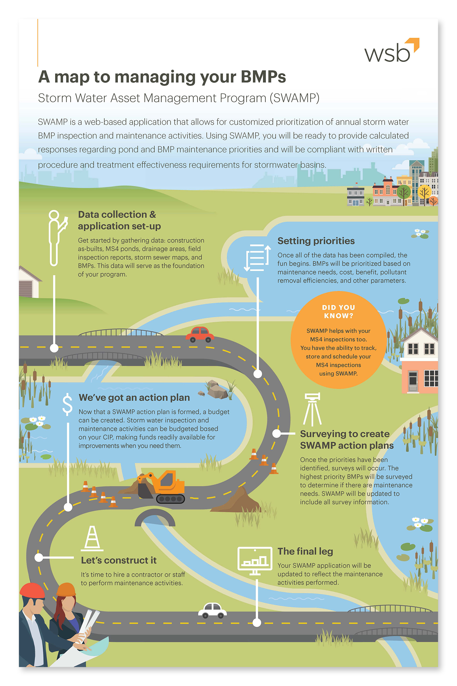
One of the main changes is new performance-based responses to Total Suspended Solids (TSS) and Total Phosphorus (TP); including a TMDL assessment to identify and prioritize activities to achieve reductions. WSB’s SWAMP system helps to address these new regulations by streamlining TMDL compliance through tracking and documenting improvements that have been completed to date or since the baseline of TMDL development. The SWAMP system also helps target subwatersheds that are underperforming or lacking the necessary treatment to meet water quality goals. SWAMP improves efficiency by saving time on planning and modeling when developing an efficient plan to address TMDL requirements.
Aside from improving compliance with new MS4 TMDL requirements, SWAMP continues to help address existing MS4 requirements.
Estimate TP and TSS reduction from existing ponds and BMPs
Prioritize inspection and maintenance activities related to ponds and BMPs
Ensure standard operating procedures are in place and stormwater management features continue to function as designed
Inspection and maintenance activities are automatically updated and reflect real-time information
Tracks and stores completed activity records for on-demand reporting
Jake has more than 15 years of engineering experience designing and managing many types of water resources projects, including modeling, planning, design, maintenance programs, and construction. Jake has worked with various municipalities, counties and state agencies to solve challenging water quality and water quantity problems.
Implementing the Modified Unified Technique on Hanson Lake.
Asian carp are some of the newest invaders of our lakes, rivers and streams. Asian carp is a term used collectively to describe bighead carp, black carp, grass carp and silver carp. Fast growing and invasive, these specific fish are causing problems along the Mississippi River and surrounding bodies of water.
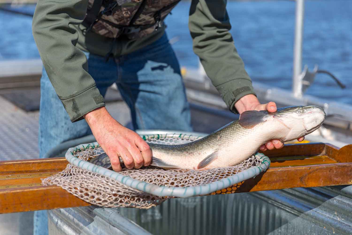
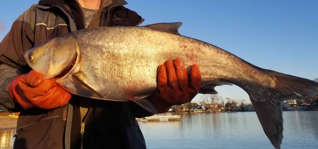
Asian carp are labeled as invasive because of their effect on ecosystems, water quality and native fish populations. Like the Common carp, Asian carp are highly invasive and have disrupted our food web. In 2019, Hanson Lake #3 Homeowners Association (HOA), located in Nebraska, commissioned the WSB natural resources team to address the growing Asian carp population in the lake. The lake’s recreation had taken a hit because of the carp’s ability to fly out of the water, disrupting boaters and swimmers.
Hanson Lake is unique. In the past, commercial fishing crews had identified high populations of Asian carp, but effectively trapping and netting the fish was challenging due to obstructions at the bottom of the lake. These obstructions were preventing the nets from capturing the fish.
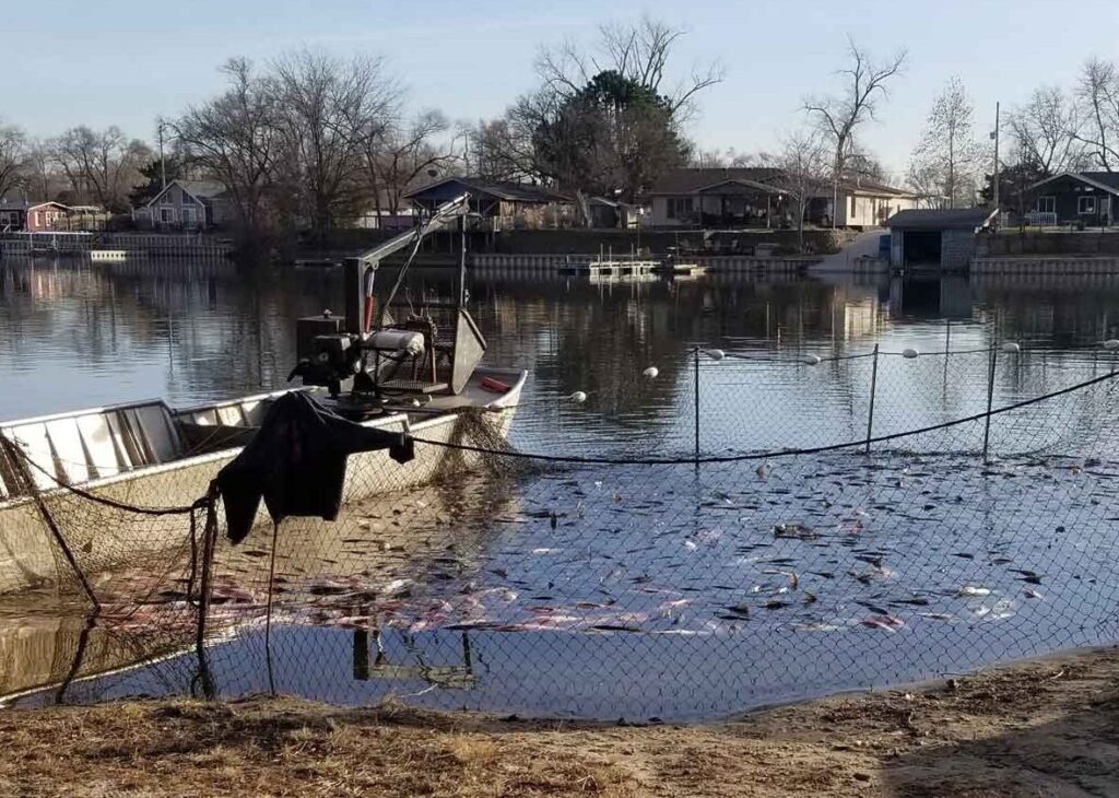
With many non-nettable locations located throughout Hanson Lake, we needed to find a solution that would drive the invasive carp into areas where we could capture and extract them. A few years ago, I read about a new harvesting technique developed in China called the modified unified technique. Using this technique, fish are herded into a concentrated area where they can be easily netted and harvested. The technique requires the use of underwater speakers and block nets.
In collaboration with the United States Geological Survey (USGS), we decided to implement the Modified Unified Technique on Hanson Lake. We connected underwater speakers to amplifiers and played a pattern of noises including ice cracking, feedback, human voices, gunshots and hammering. The pattern of noises was played on repeat to begin herding the fish into the waiting nets. Throughout several days, the sound waves drove the fish into the nettable areas of the lake where seine nets were placed.
Once the harvest was complete, over 26,000 pounds of rough fish were removed from Hanson Lake. Comparatively in 2018, 8,200 pounds of fish were removed from the lake. Rough estimates indicate that over 30 percent of the lake’s rough fish were removed during this operation which will significantly improve recreation and water quality in the area.
What’s so bad about Asian carp?
Aquatic Invasive Species are behind some of the most drastic changes to freshwater systems in the world today. According to the U.S. Department of Agriculture, Asian carp were first brought to the United States for use in aquaculture ponds. These fish have now invaded the Mississippi River that connects to many bodies of water throughout the nation. Natural Resources organizations and groups are fearful that Asian carp will invade the Great Lakes which would have a severe impact on recreational and commercial fisheries. Many cities, counties and watersheds are taking proactive steps to mitigate the invasive species to protect and preserve the ecology and water quality throughout the nation.
The countdown to the release of the updated MS4 Permit has begun. The current MS4 Permit expired on July 31, 2018 and the MPCA is tentatively planning to reissue the updated Permit before the end of this year.
As a new permit approaches, take a few minutes to reflect on the progress you’ve made towards meeting your measurable goals over the last five years. We’ve developed procedures, adopted ordinances, formed partnerships, inspected and eliminated illicit discharges, monitored construction sites, and assessed our ponds…and now it is time to start thinking about the next permit cycle.
Soon we will work through the Part II application that outlines how our MS4 programs will come into compliance with the updated MS4 Permit requirements. Before the new MS4 Permit is released, there are some important to-dos to help you get organized before the permit arrives.
Here’s what you can do now:
Review and update your storm sewer system map. Take a close look at storm sewer, pond, outfall, and structural stormwater BMP locations and ownership information and complete updates, as needed.
Dust off ordinances, written procedures, enforcement response procedures, form templates, and save them in a convenient location – they’ll come in hand for the Part II application.
Complete a mock audit. By understanding the current state of your program compared to the existing requirements, you’ll be ready to fill in the blanks in the Part II application with ease. As a bonus, this activity will also help you start preparing for the 2020 MS4 Annual Report; a bit of preparation this fall will save hours of agony in June.
Organize your files and recordkeeping mechanisms. Consider creating a shared drive so everyone on your team can help track and contribute to MS4 activities. If your current set-up isn’t working, now is the time to find a system that works for easy tracking for the next permit cycle.
Continue the routine upkeep of your MS4 program to keep operations running smoothly, including staff training, erosion control inspections and enforcement, public education efforts, annual meeting, etc. The permit may be expired, but we must continue to implement our programs and ultimately manage our stormwater conveyance systems.
Start checking things off your list, and in no time at all, you’ll be ready to take-on whatever the new MS4 Permit has in store.
Meghan Litsey is director of our Environmental Compliance team and has over eight years of experience. She specializes in providing environmental compliance services in construction site permitting, SWPPP design and inspection, and MS4 program development.
Many groundwater sources in the United States have elevated levels of nitrate, which can lead to public drinking water suppliers exceeding the Environmental Protection Agency’s (EPA) Maximum Contaminant Level (MCL) limit of 10 mg/L. Regularly consuming water with nitrate concentrations above the MCL can reduce the oxygen-carrying capacity of the blood; resulting in shortness of breath and possibly fatality in humans. Conventional approaches to treating nitrate include ion exchange or reverse osmosis, both which are effective but generate large quantities of brine salts leading to multiple environmental concerns.
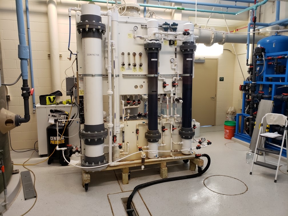
WSB has successfully removed nitrate from the groundwater without generating harmful residuals using biological filtration. Biological filtration removes nitrate through denitrification. Denitrification is the process by which nitrate is removed from the source water by converting it to non-toxic nitrogen gas (78 percent of the air we breathe is comprised of nitrogen). Biological filtration employs conventional filters to clean the source water. However, the filters are populated with naturally occurring microbes that enable the biological conversion of nitrate. Both the Minnesota Department of Health (MDH) and the EPA consider biological denitrification to be an efficient and effective method for treating nitrate in public drinking water supplies, additionally, it significantly reduces the amount of chemicals used and generate significantly fewer residuals. An external carbon source may need to be dosed to promote microbial growth in the filters depending on the type of water to be treated (groundwater or surface water).
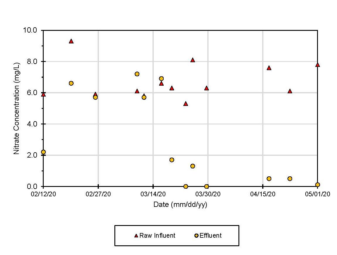
Although biological denitrification has been used in wastewater treatment for decades, it has only been effectively used in the United Stated for drinking water treatment in recent years. Therefore, MDH requires a pilot study to be completed prior to implementing this treatment process full-scale. WSB recently completed a biological filtration pilot study for the City of Hastings, Minnesota. Hastings’ water supply is provided by groundwater wells that are open to the Jordan Sandstone Aquifer. The Jordan Aquifer is a shallow and, sometimes vulnerable, aquifer that commonly produces groundwater with significant levels of nitrate. Hasting’s wells produce water nitrate concentrations that range from 6 to 9 mg/L. The city currently has an existing ion exchange water treatment plant that removes the majority of the nitrate before it enters the distribution system. The figure above shows the nitrate removal results obtained during the pilot study. The average influent nitrate concentration during the 12-week pilot study was 6.7 mg/L. WSB’s biological filtration pilot plant consistently reduced the influent nitrate concentrations in Hastings’ well water to below 1.0 mg/L. Several samples had non-detectable levels of nitrate which demonstrated the pilot plant’s capability to remove all nitrate from the City’s raw water. Nitrate removal did not occur immediately as the microbes required a couple of weeks to populate the filters in order to denitrify the water. These microbes are not harmful to humans as they are inactivated using disinfection prior to pumping the water to the distribution system. Nitrite is formed as an intermediary step between nitrate and nitrogen gas. Nitrite causes similar health effects than nitrate, but it is more toxic as its MCL is only 1.0 mg/L. Effluent nitrite concentrations were maintained at zero or near zero during the pilot study.
If your community’s source water has elevated nitrate levels, WSB’s water treatment engineers can work with you to develop a comprehensive pilot protocol, collaborate with state agencies, and conduct a pilot study using WSB’s pilot plant to help you determine if biological filtration can treat most or all of the nitrate in your raw water without generating harmful residuals. For more information, please contact WSB.
By Jake Newhall, Project Manager & Pete Willenbring, Vice President, WSB
Approaching winter conditions mean more salt in stormwater systems
Chlorides in our local bodies of water have become a rising concern in recent years. As winter weather approaches and causes icy conditions, our parking lots, roadways and sidewalks are treated with salt to melt snow and ice.
Salt creates safer winter driving conditions, but the environmental impacts of salt use are raising concerns on the long-term effects on fisheries, plant life and surrounding wildlife. The salt used to treat our roadways and pedestrian areas contains chloride that dissolves when mixed with water. This has resulted in increased chloride concentrations in many lakes, streams, and wetlands. The elevated chloride levels are high enough in some cases to cause significant environmental impacts.
Removing chloride from water is possible, but the technology is incredibly expensive, and disposal of the chloride removed is a challenge. The primary way to remove chlorides requires high-tech reverse osmosis filters. This is not unlike the challenges presented in treating ocean water for potable source water.
Monitoring the runoff and impacted surface water bodies in areas where heavy salt application is occurring is allowing us to gain a better understanding of the effects of chlorides on our environment and how communities can manage application rates to balance public and environmental safety.
In recent years, WSB has been working closely with state and local agencies to monitor and track the application, runoff concentrations, and ultimate impacts of chlorides in various locations. The goal is to develop a better methodology to manage the application, potential chloride disposal opportunities, and minimize environmental impacts. Through this research, we’ve been exploring ways to reroute chloride-saturated runoff away from local surface waters and BMPs and protect them from elevated concentrations.
As we continue to monitor and evolve our understand of chlorides, we are developing several initiatives with cities, watersheds, and the Metropolitan Council that will allow us to balance future management strategies, public safety, and environmental impacts of chlorides.
Jake has more than 15 years of engineering experience designing and managing many types of water resources projects, including modeling, planning, design, maintenance programs, and construction. Jake has worked with various municipalities, counties and state agencies to solve challenging water quality and water quantity problems.
Pete is a principal and co-founder of WSB. He is a professional engineer, with over 30 years of experience providing consulting services to over 100 city, county, state, and federal clients. Pete has expertise in most fields of civil engineering, but is widely recognized to have developed special expertise in the fields of water resource and environmental engineering, project management, design, and planning.
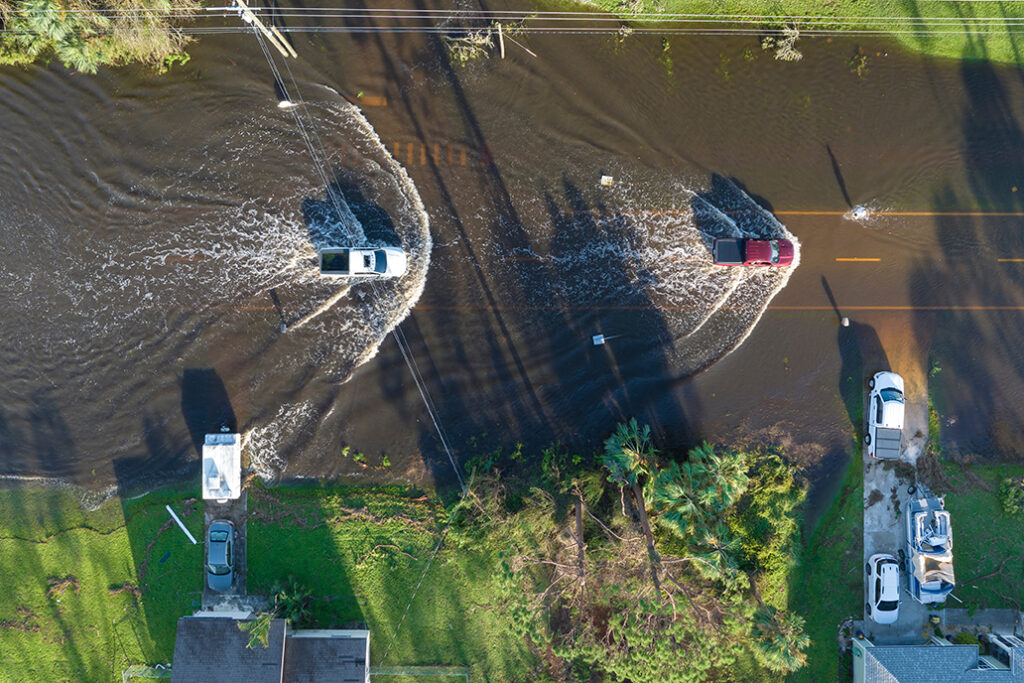
Plan ahead. Identify areas of highest risk in your city early. Develop action plans that include back-up generators and pumps, sandbags, and resident notification.
Identify, map and maintain overland overflow routes for water bodies where feasible. These routes allow runoff to follow streets, property lines, and backyards while protecting homes from high flood levels. Inspect and enforce keeping these overflows clear – no fences or outbuildings that may block drainage.
Look for opportunities to build resiliency into the system. This may mean allowing for parking lot flooding to protect structures; constructing additional ponding retention with new developments; utilizing park space, public open space, and golf course greens for flood retention.
It’s a mouthful. And it happens every day in every wastewater system, but it happens without many of us knowing about it. The sources vary, the flows vary, and the solutions vary, but the motivation to mitigate I/I is the same. The addition of excessive clear water (I/I) into local and regional wastewater systems can have many effects including basement backups, wastewater overflows, the excessive use of remaining pipe capacity reserved for future growth, and added treatment costs.
Inflow and Infiltration – or I/I – are terms that describe clear water that enters wastewater collection systems through defects and consumes treatment and conveyance capacity. Typical sources of I/I are broken service laterals, connected sump pumps or downspouts, aged or defective sewer mains, and deteriorated maintenance holes.
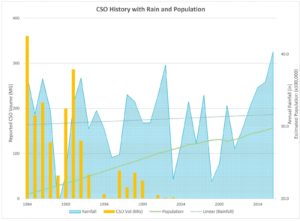
Even though many communities were developing and implementing programs to eliminate combined sewer connections decades beforehand, the story of I/I in the Twin Cities effectively begins in July 1987. Yes, the superstorm of ’87. It had big impacts 30 years ago: sewer overflows to rivers and lakes, flooded basements, comingled water in our streets, and a lingering series of videos on the internet highlighting top-notch 1980s meteorology reporting. In some areas, reported rainfall exceeded 10 inches in one day, as part of the 16 inches experienced over much of the metro region that week. It was even the second wettest summer on record (2016 was the wettest).
The storm and its effects spawned a series of studies to understand the impacts of I/I on wastewater systems throughout the region. A 1990 study by MCES concluded that roughly one-fifth of wastewater treated in the region was from I/I. It was clear (pun intended) that the wastewater systems needed some rehabilitation, and that source removal would have a significant impact on reducing base and peak flows from I/I. In response, communities and MCES ramped-up efforts on I/I mitigation and combined sewer disconnection. After years of investment, peak flows and combined sewer overflow (CSO) volumes had been reduced, but not eliminated.
In 2004, the first MCES I/I Task Force – representing communities served by the regional wastewater system – recommended a long-term systematic approach to reducing peak flow, now known as the Ongoing I/I Program, which is administered by MCES. The superstorm is still having effects today as communities throughout the region work to repair their systems before an event of that magnitude happens again. During much of the last decade, the efforts to mitigate I/I have focused on repairing sewer mains and maintenance holes through lining or replacement projects. There has also been significant effort into mitigating surficial inflow sources such as vented MH covers, rain leaders, and roof drains.
There is evidence of success from all this effort.
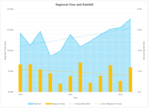
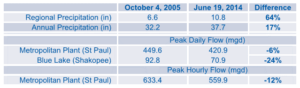
At the regional level, there is a diverging trend, with rainfall totals increasing and wastewater flows decreasing, even as the population has increased. Also, by comparing major rainfall events in 2005 and 2014, regional precipitation increasing by 62% in the weeks leading up to the 2014 event, but the peak wastewater flow at the Metro Plant in Saint Paul decreased by 12% for peak hour and 6% for the peak day. However, almost half of communities in the region discharged excessive I/I during the 2014 event.
So, what’s next? When the Ongoing I/I Program began in the early 2000s, the estimated cost to mitigate excessive I/I into the regional system was largely based on removal of sources at the far upstream ends of the systems – namely from private infrastructure such as service laterals and sump pumps. Many communities have worked to eliminate sump pump connections, and some have instituted programs to inspect and repair service laterals. And it has worked. In a 2016 flow study, communities that included private infrastructure as part of their I/I mitigation strategy were able to achieve up to four-times greater reductions in peak flows than those that focused on public sources.
Being the proverbial low-hanging fruit, it’s understandable that many communities have focused on the easily-accessible public infrastructure. And that’s why the MCES I/I Task Force identified some specific strategies to address the technical and financial challenges of private property I/I mitigation. The main outcomes will be increased public outreach (you’re reading some now), technical support, and continued support for funding of public and private I/I mitigation. Why the focus on private infrastructure? In the words of the latest task force:
“Private sewer service laterals represent a significant portion of the overall collection system but are often not part of public system inspection, replacement, or I/I mitigation programs. These service laterals tend to represent an unquantified and unresolved share of the I/I problem. Another reason is because previous studies indicate that up to 80% of I/I is from sources on private property.”
MCES is in process of completing the recommendations of the task force, with most planned for launch in 2018. Communities can expect to see an updated public outreach toolbox intended to share simplified communication materials in a variety of formats. They can also expect more details on an I/I mitigation demonstration project that would provide additional opportunity for measurement of the impact on wastewater base and peak flows. The recommendations are located in the 2016 I/I Task Force Report. A common theme of the recommendations is using regional resources to support communities with effective decision-making and implementation of their respective I/I mitigation strategies.
Anyone interested in more information on the program or the demonstration projects is encouraged to visit the program website at www.metrocouncil.org/iandi or email the team at [email protected].
And if you have more to add to the regional story about I/I mitigation or the superstorm, we’d be happy to have it! Photos and videos, reports, anything you have. There’s a wealth of information throughout the region, and it would be great to capture that. Marcus Bush, PE is a Principal Engineer for the regional wastewater treatment provider, Metropolitan Council Environmental Services. He administers the Ongoing I/I Program that provides resources and incentives to communities for mitigating excessive flows due to I/I. Prior to his role with MCES, he worked in municipal and environmental engineering, land development, industrial brewing, and the bicycle industry.
Marcus Bush, PE is a Principal Engineer for the regional wastewater treatment provider, Metropolitan Council Environmental Services. He administers the Ongoing I/I Program that provides resources and incentives to communities for mitigating excessive flows due to I/I. Prior to his role with MCES, he worked in municipal and environmental engineering, land development, industrial brewing, and the bicycle industry.
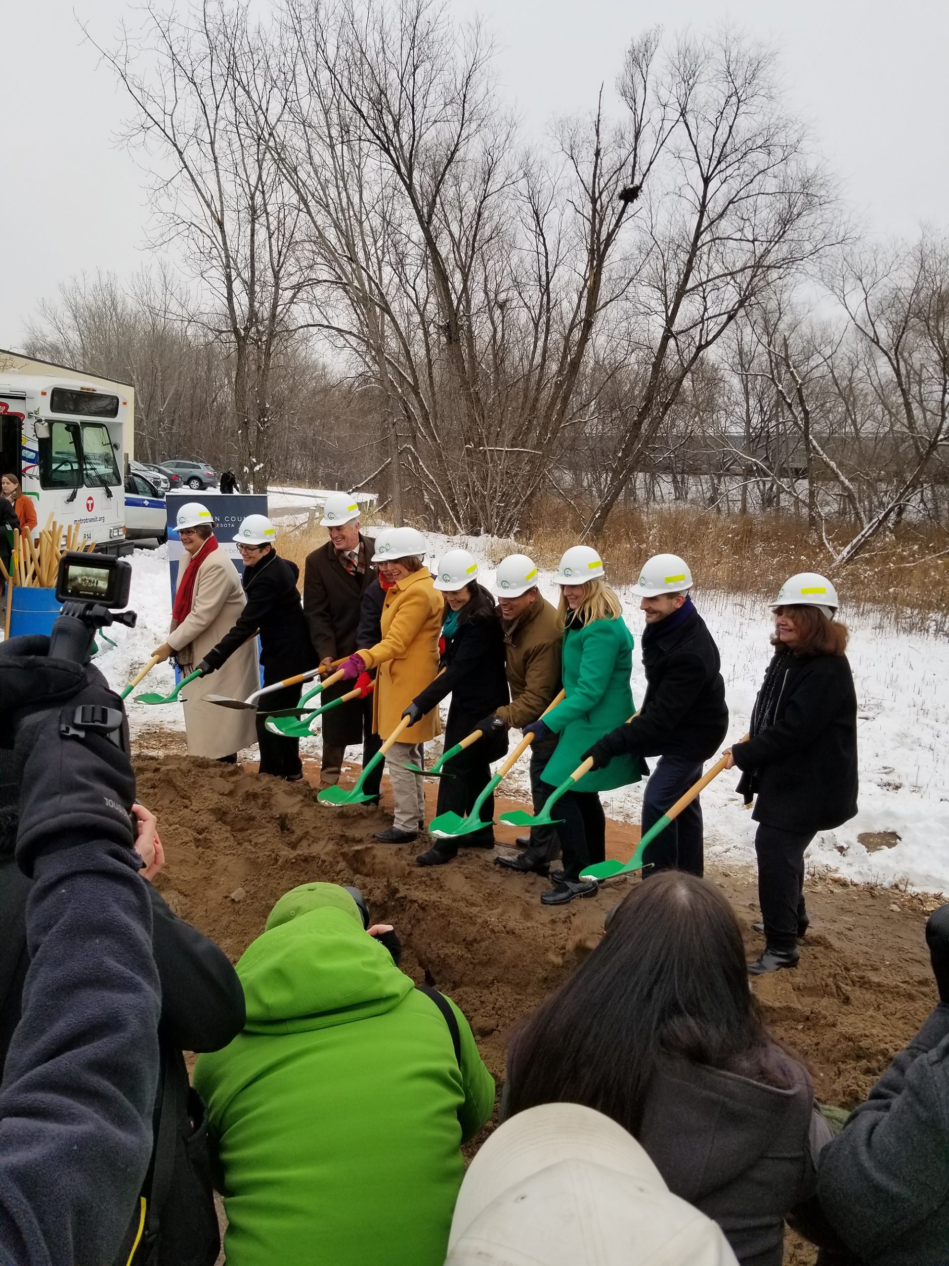
One of Minnesota’s largest infrastructure projects officially moves into construction.
WSB acted as West Segment Water Resources Lead for Metro Transit.
Federal, state, and local officials gathered in Hopkins to break ground on the Southwest LRT project in late November. The $2.003 billion project will be the largest infrastructure project in the state’s history and is expected to create 7,500 construction jobs, with an estimated $350 million payroll.
Our Water Resources and Environmental Compliance teams assisted Metro Transit as the West Segment Water Resources Lead. We completed the erosion and sediment control design, storm sewer design, permitting, bridge and wall drainage work. Our team was also responsible for identifying and designing Best Management Practices (BMPs) to meet permitting requirements and designed the storm sewer infrastructure that will connect existing municipal and Minnesota Department of Transportation (MnDOT) systems to one another. Additionally, we prepared water resources-related documents, including preparing plans and specifications, quantifying wetland and floodplain impacts, completed hydraulic analysis for risk assessments and performed water quality analysis of the proposed BMPs.