October 16, 2023 By Steve Nelson, Director of Water/Wastewater, WSB
The Minnesota Department of Health (MDH) and the Minnesota State Fair (MSF) are an unlikely duet, yet in 2023 they are singing the praises of Biological Filtration.
The Minnesota Department of Health – Acknowledged Biological Filtration’s ability to naturally achieve Optimal Corrosion Control Treatment (OCCT) and compliance with the Revised Lead and Copper Rule (LCR), in lieu of adding very expensive manmade chemicals like orthophosphate.
The Minnesota State Fair – Le Sueur Minnesota, a community which WSB’s director of Water and Wastewater helped convert to Biological Filtration in 2013, was awarded third place among communities with the best tasting water at the 2023 State Fair.
The Corrosion / Taste Connection:
Biological Filtration ensures that all nitrification (the conversion of ammonia to nitrate) occurs in the water treatment plant filters and not in the finished water distribution system; it also allows for the addition of chlorine after complete nitrification has occurred.
Avoiding nitrification in the distribution system is THE critical factor in the successful control of corrosion in Minnesota ground water systems.
Achieving complete nitrification prior to the addition of chlorine vastly improves the ability to achieve and maintain great natural tasting water in the distribution system and all the way to the consumer’s tap.
Current Studies Reveal Other Practical Benefits:
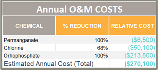
WSB is piloting biological filtration for several metro area communities. Some of these communities are considering harnessing biological filtration to reduce capital and chemical costs for their future water plant expansions. Orthophosphate would not need to be added if Biological Filtration is approved as the OCCT. The currently projected capital and chemical savings for one of these communities are as follows:
How WSB Has Helped and Can Help
For decades, Steve Nelson has been teaching about Corrosion Control, singing the praises of Biological Filtration and making the connection between the two. “It is now a joy to see our local communities harnessing nature to produce safe, sustainable, solutions that provide natural corrosion control, reduced capital costs, reduced chemical costs and improved taste at the consumer’s tap.” (Steve Nelson, WSB)
Interested in pursuing or exploring how biological filtration systems can improve your community’s water? Reach out to our team of experts to get started.
Steve designs treatment plants and renovations (for both groundwater and surface water plants) including treatment process technologies such as reverse osmosis, ozone, activated alumina, biological filtration, lime softening, radium reduction, plate settlers, plate and frame presses and solids handling. He has worked with the AWWA Office of Government Affairs and the AWWA Research Foundation on water studies.
October 16, 2023 By Steve Nelson, Director of Water/Wastewater and Jon Christensen, Project Manager, WSB
Smart city technology has proven to be a game changer in water management, revolutionizing how cities handle their water resources. Smart cities are leveraging innovation to improve water management, leading to increased efficiency, cost savings and proactive decision-making. Technology adoption to gather data, enhance operations and plan improvements has become vital in progressing toward more streamlined and effective utility infrastructure.
How can your community benefit from smart water management? Here are three things to consider.
Efficiency through Technological Solutions Smart cities optimize water management processes with accurate and real-time data, allowing for increased infrastructure efficiency, which reduces energy consumption and lowers costs. Integrating computer models, field data and Supervisory Control and Data Acquisition (SCADA) systems can streamline operations and identify areas for rehabilitation or improvement in a water system.
Transforming the Water Management Lifecycle The impact of smart city technology is not limited to one phase of water management; it permeates the entire lifecycle. From the initial planning, design and construction stages to operation, maintenance and ongoing asset management, smart technology plays a vital role at every step. During design and construction, resources like 3D modeling create more accurate visual representations of supply, treatment, storage and distribution facilities and streamlines stakeholder and contractor communication, ultimately enhancing project outcomes.
Once construction is complete, smart city technology continues to support asset management. 3D virtual models and Building Information Modeling (BIM) coupled with field data enables cities to monitor the condition of infrastructure, identify areas that require maintenance or rehabilitation and optimize around fluctuations in energy rates. By employing proactive strategies, cities can minimize disruptions, extend the lifespan of infrastructure and reduce operational and long-term costs.
Proactive Decision-Making and Risk Management Smart cities’ ability to be proactive in their water management practices sets them apart. By continuously monitoring and analyzing data, cities can detect potential issues before they escalate and prioritize rehabilitation and replacement budgets. Predictive analytics allow municipalities to identify potential issues and replace aging water main lines in advance of breaks and failures. This proactive approach minimizes disruptions to residents, improves service reliability and reduces emergency repair costs.
How WSB Can Help Your Community Be Smart About Water Management
WSB adopts a strategic approach to water management in smart cities, from planning, design and construction to asset management and beyond. Using state of the art technology and data-driven insights, we enhance project execution and improve asset management. Our approach enables cities to leverage smart technology in delivering high-quality water service to their residents and businesses.
Steve designs treatment plants and renovations (for both groundwater and surface water plants) including treatment process technologies such as reverse osmosis, ozone, activated alumina, biological filtration, lime softening, radium reduction, plate settlers, plate and frame presses and solids handling. He has worked with the AWWA Office of Government Affairs and the AWWA Research Foundation on water studies.
Jon’s experience in water and wastewater engineering include water supply systems, sanitary sewer collection systems and water and wastewater treatment facilities. Prior to joining WSB, Jon spent two years with an NGO in Honduras designing and constructing electricity-free sustainable drinking water treatment plants.
Geographic Information Systems, or GIS, have become indispensable tools for cities of all sizes in their quest for efficient data management, smart decision-making and improved civic engagement. GIS is a technology that allows for the capture, storage, analysis and presentation of spatial data. This system combines geographic information with other forms of data, offering a unique perspective on various aspects of a city. Insights from GIS can drive sustainability outcomes, advancing economic, social and environmental benefits, as well as many other benefits that help advance city goals.
Today, many communities are sitting on a vast amount of data, but unsure how to aggregate and access it all in one place. These communities tend to also have the software tools and licensing necessary to use this data in the correct manner, namely Esri’s ArcGIS Online. These communities then already have all the data and tools they need to be successful with their GIS data, they just need assistance in putting the pieces together. WSB recently worked with two cities in Minnesota – Hastings and Saint Michael – to audit and organize their data, ensuring they were able to unlock its full potential.
What Kind of Data are Cities Collecting?
Small to midsize cities stand to gain significantly by harnessing the power of GIS. When thinking about how to best utilize data, it’s important to understand what data is available. GIS data communities are collecting, include:
Public Utility Data: Efficiently managing utilities data, including sewer, water and gas pipelines is critical. GIS data can help cities maintain these systems effectively, while minimizing disruptions and enhancing public service.
Community Development Data: Understanding land use and zoning is crucial for urban planning. With GIS, cities can optimize land use, improving infrastructure and the allocation of resources.
City-Created Data: Cities can aggregate data for specific needs and uses. Collecting and analyzing data related to city services, demographics and infrastructure can lead to smarter decisions and resource allocation. Moreover, cities can extend the benefits of GIS to the community by increasing data accessibility and conducting community outreach. For instance, some cities are surveying residents to compile data on doorbell cameras which can help law enforcement solve crimes.
Who is Using the Data?
Just as important as understanding what data is available, it’s important to understand who should have access to the data. Public works and engineering staff should have access for maintenance, repairs, planning and asset management. Community development teams can utilize data to create story maps. And ultimately, a case can be made for every city department to have access to data in some form to help drive collaboration, communication and a shared understanding of city priorities.
Where Should Cities Start?
When WSB worked with Hasting and Saint Michael to organize data, this is how we effectively gathered and aggregated their data into one platform.
Perform a data and software review. What programs are being used and does the city need additional licenses? Doing an audit of this information is a good place to start.
Prepare data for ArcGIS Online. Standardizing the data across platforms ensures that when it is all moved to be housed within one program, data is understandable, accessible and usable.
Publish all data to ArcGIS Online. Once the data is standardized, all information is uploaded to ArcGIS Online, Esri’s cloud infrastructure.
Create web applications and web maps. Now that data is all in one place, creating applications is important so users can access the data they need. Not all licensed users will need access to every bit of information. Applications make the data more usable and ensures that if data is updated by one user, it is reflected across the cloud.
Train staff to understand the program and use the applications. Data is only useful if it’s understandable. WSB works with cities to train staff on how to access, update and utilize data within the cloud and related applications.
When it comes to GIS services, WSB is the ideal partner for small to midsize cities. WSB offers the expertise of a team with decades of experience in GIS and related services, guaranteeing that your city’s data is in capable hands. Furthermore, WSB’s commitment to direct municipal collaboration means that they thoroughly work to understand the unique challenges and opportunities that cities face, ensuring that GIS solutions are tailored precisely to your specific needs.
November 13, 2023 By Ryan Spencer, Director of Environmental Investigation and Remediation, WSB
Many communities and developers in Minnesota are sitting on brownfield properties that have the potential for redevelopment, but first need to be investigated for potential contamination. With approximately $2 million coming into our state from the federal government’s bipartisan infrastructure law, now is the time to take advantage and apply for the MPCA Brownfield Assessment Grant.
According to the MPCA, there are many groups that can and should apply for these dollars. They include, but are not limited to:
Community organizations
Local units of government
BIPOC developers
Emerging developers (developers who have completed 5 or fewer projects)
Tribal entities
Environmental Justice Zones
MPCA Brownfield Assessment Grant funds are targeted at areas of environmental justice. That could include underserved communities, low-income neighborhoods or areas with a significant BIPOC population. It’s important to remember that environmental justice zones do not only fall in urban centers, but also in many rural communities.
This specific grant will fund either Phase I or Phase II environmental site assessments. Phase I relates to the standardized environmental assessment of a property, and Phase II is the physical sampling of soil and other properties to determine if contamination is present.
The brownfield grants may also be used for sampling and analysis work plans, hazardous materials building surveys to identify lead-based paint and asbestos-containing materials, preparation of cleanup response action plans, community engagement for reuse planning, and MPCA Brownfield Program fees.
When is the best time to apply?
The grant is an ongoing grant, with dollars available from 2022-2027, so it would be great to apply anytime. The application is relatively quick and those who are eligible should absolutely take advantage of this opportunity.
Moreover, because federal stimulus dollars are flowing into the state, the MPCA wants to take those dollars and put them to work. They are strongly encouraging interested applicants to apply.
How WSB Can Help
Do you have a brownfield site and are interested in applying for these grants? WSB can help.
WSB’s team of experts can assist with grant applications, clean up, response planning that ensures full alignment with all regulatory requirements and helping communities identify brownfield sites that would benefit from development.
Ryan Spencer is our director of Environmental Investigation and Remediation and has worked in the environmental consulting industry servicing both public and private sector clients. He is proficient in the planning, management, and completion of environmental due diligence, remediation, and brownfield grant writing.
December 7, 2023 By Andy Kaiyala | VP of Construction Technologies and Controls, TX, WSB
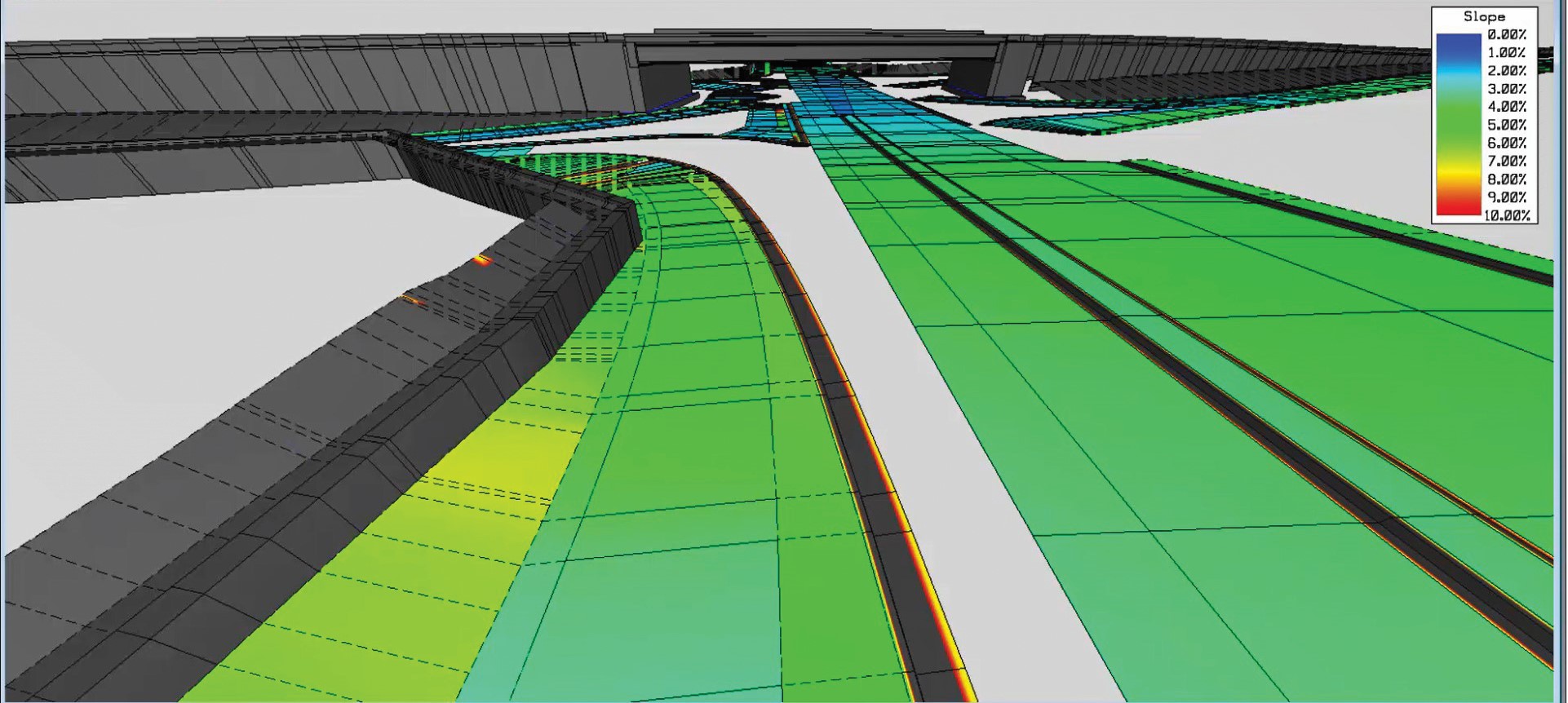
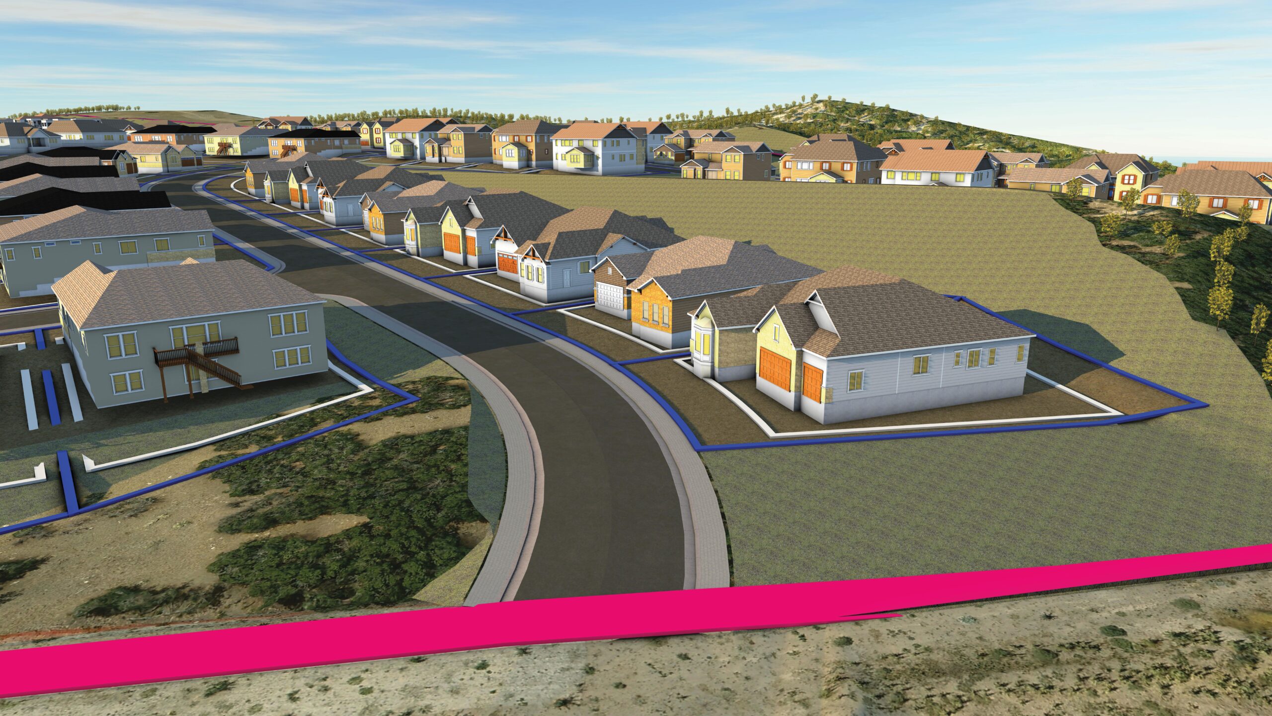
In an ever-evolving construction industry, Digital Construction Management (DCM) is the future of our industry. Utilizing cloud-based connected data environments that visualize the physical world in an interactive digital space is the next step to advance civil construction project delivery. This undertaking will produce accurate 3D models that become the single source of truth for project delivery, with each stakeholder building upon the work of the previous.
Simply put, this is the future of civil infrastructure and WSB is at the forefront with our DCM service.
Defining Digital Construction Management Digital Construction Management represents a paradigm shift. At its core, DCM is the fusion of advanced technology and traditional construction practices that allows all stakeholders to evaluate the same data and make smart decisions.
The shift from 2D to 3D workflows will not occur overnight, but we recognize the value of 3D modeling and its ability to provide a more comprehensive and intuitive view of a construction project. 3D models enable stakeholders to visualize the project in its entirety. Where are utility clashes? Where are the trouble spots that need to be addressed? How will shifting elements of a project play out in the real world?
DCM has far-reaching implications for every stage of a construction project, from design to execution.
Unparalleled Problem Solving Every project comes with risk, but DCM helps create the opportunity to take risk from an abstract concept to a concrete reality so challenges can be solved efficiently. When the proposed design is analyzed in context of a full existing-conditions model, problems are identified early, risk is mitigated and projects are ultimately more efficient and cost-effective.
Putting the Design Model to Work WSB is excited about DCM because it is the intersection between services and software, and what is next for our industry. WSB provides both cutting-edge software tools and the expertise to use them effectively. DCM enhances our clients’ capabilities, allowing them to integrate operational data within one platform from the very earliest stages of the project through construction close out.
WSB’s in-house DCM expertise spans construction modeling, visualization, design modeling, 4D scheduling, data analytics, project controls, IT development resources, constructability review and automated machine control. This holistic approach ensures that every facet of the project benefits from DCM.
Preparing for the 3D Future WSB’s approach to Digital Construction Management is about meeting clients where they are today while preparing them for the future.
The future of construction is digital, and our DCM services are empowering clients to make informed decisions while fostering collaboration, utilizing data intelligently and mitigating risks.
The digital future is here, and WSB is leading the way.
Andy is Vice President of Construction Technologies and Controls with over 25 years of industry experience and emphasis on large, complex, alternative delivery infrastructure projects in the transportation, heavy civil, flood control, and transit spaces. Andy has led teams that secured construction projects with a contract value of more than $5B in nine states and three countries.
By Brian Bourassa, Vice President of Corporate Development, WSB
At WSB, we build what’s next in infrastructure—the places, spaces and systems that support our lives. We take pride in supporting communities across the country on a wide variety of projects. With over 30 complementary services within engineering, community planning, environmental and construction, we support the commercial, government and energy markets. From city to state, land development to facilities, and energy utilities to renewable energy— we build for people and the future.
Energy
UTILITIES, SUMMIT UTILITIES
There is a lot of potential in the energy market, and we continue to lead the industry with advanced project delivery. In Arkansas, we perform utility work for Summit Utilities through inspection as well as utility mapping. Through this work, we have digitally mapped a large portion of new installations. Utility mapping is the future, and the safety and efficiency benefits are significant.
RENEWABLE ENERGY, SIGNAL ENERGY
Renewable energy is creating a more sustainable future. Across the country, we’re supporting utility scale solar fields and community solar gardens. Community solar gardens are constructed on smaller tracts of land within a specific geographic location and provide energy to individuals, businesses, nonprofits and other groups. A recent project we supported is Clearway Cokato in Minnesota. This 4-Megawatt community solar garden was distributed across 20 acres of land. We also provided infiltration trenches as stormwater management BMP’s.
Commercial
LAND DEVELOPMENT, CRYSTAL VALLEY RANCH DEVELOPMENT, CO
The Ridge is a 142-lot subdivision on 160 acres located within Crystal Valley outside of Denver, Colorado. This Crystal Valley Ranch property proved to be one of the most complex subdivisions ever completed by our land development team due to some challenging features. The project included steep grades, limited connection points, adjacent existing subdivision tie-ins, the creation of an entirely new pressure zone in the town’s water system and preservation of existing Gambel oak and view plane restrictions.
FACILITIES, KELLEN RESEARCH BUILDING AT MAYO CLINIC
We support many large facilities, including buildings on healthcare campuses. At the Kellen Research Building on the Mayo Clinic campus, we provided geotechnical inspections, vertical and civil special inspection services and GPR for the research building. Additionally, we provided land surveying, civil engineering and landscape architecture design.
CONSTRUCTION, UNIVERSITY OF MINNESOTA – DULUTH
Recently, we have partnered with the University of Minnesota-Duluth to improve campus infrastructure. A project of note was the replacement of the heating plant underground storage tanks along with new asphalt and concrete pavements and sidewalks. Another involved replacing severely worn entrance roads, sidewalks and parking lots and improving crosswalk safety for the Chester Park building. For each of these projects WSB provided materials testing and special inspection services.
Government
SAFETY IMPROVEMENTS, CITY OF BRAINERD, MN
We recently supported the city of Brainerd’s Oak Street Improvement Project in front of Harrison Elementary School, a roadway that warranted several improvements to improve safety of pedestrians and students crossing the busy corridor. The $500,000 project was fully funded by the Safe Routes to School grant program. The road was reconstructed with a median, Rectangular Rapid Flashing Beacons (RRFBs), and appropriate pedestrian signage to improve awareness and safety of pedestrians crossing the roadway.
CIVIL ENGINEERING, HAYS COUNTY, TX
WSB provided plans, specifications and estimates (PS&E) for RM 967 in Hays County. The $6.6 million project added several improvements such as widening lanes, adding a continuous left turn lane, additional lanes at intersections and safety shoulders to 4.4 miles of the minor arterial. Beyond this, many traffic and pedestrian signals were improved, reducing congestion-related delays. Several innovative design elements were involved in making this project successful including designing a portion of the project non-symmetrically and developing a new construction approach to avoid relocation efforts.
CIVIL ENGINEERING, NORTH DAKOTA DEPARTMENT OF TRANSPORTATION
We recently performed a grade raise on ND 14; a roadway of regional significance backed by Emergency Relief funding. The goal of the project was to improve safety, specifically to expand flood risk protection. WSB supports roadway projects with many services, but this project included construction inspection and contract administration.
TRIBAL SUPPORT, MANDAN HIDATSA AND ARIKARA (MHA) NATION
WSB is part of a multi-disciplinary team designing a new high school campus in Twin Buttes, North Dakota. The comprehensive project encompasses constructing a school building, a large sports stadium featuring artificial turf, a sports dome, and a residence hall. Our role in this endeavor extends to spearheading critical site components, including civil engineering, permitting, and landscape architectural services. This project holds immense significance due to its commitment to incorporating indigenous values into the curriculum and addressing a vital need within the community. The closest existing high school is over 40 miles away, making this initiative an essential step toward providing accessible education for the local population.
Brian is a registered professional engineer with over 30 years of experience in many types of municipal and general civil engineering projects including streets, parking lots, storm sewers and drainage, water distribution systems, sanitary sewer systems, site grading, park improvements, infrastructure reconstruction, and tribal communities. Brian’s experience includes all phases of the project including feasibility study, design documents. bidding process and construction administration.
As technology evolves, so does the way we harness information. Geographic Information Systems (GIS) have emerged as a transformative technology, empowering organizations with location intelligence. At WSB, GIS isn’t just about maps; it’s about turning geospatial data into a powerful asset that fuels innovation and smart decision-making for clients. The work we do with integrating GIS with other systems provides a dynamic data-driven insights and action.
Foster Data-Driven Asset Management and Community Engagement
For government and municipal clients, GIS is a cornerstone technology. It doesn’t just create maps; it’s a system of record-enabling, efficient asset management. GIS is a system of engagement and can empower greater community insight. In Duluth, Minnesota we helped implement a GIS-driven app for citizens to report issues to the city like graffiti, downed signs or potholes. Appls like this bring maps, data and people together in real time.
Drive Private Sector Solutions
For commercial clients, GIS can help mitigate risk and drive informed decisions. For example, we collaborated with an insurance data analytics provider to infuse GIS into their products allowing them to offer a more cohesive approach to analyzing risk. GIS provides geospatial data-driven insights and predictive analytics that insurance carriers use to reduce risks and improve policyholder retention. This, in turn, empowers businesses to strategize effectively, minimizing potential losses and optimizing their operations.
Enhance Safety and Prevent Damage
Energy companies leverage GIS to enhance safety and prevent damage. These technologies provide location intelligence tools that can pinpoint potential risks and vulnerabilities with infrastructure and operations. This proactive approach enables energy companies to make informed decisions that protect their assets and improve operational customer safety.
Support Multi-Dimensional Projects and the Future of Data
As project operations become more complex and interconnected via technology, so do the dimensions of data. Our GIS solutions are future-ready, supporting integrations with Building Information Modeling (BIM) for 4D and 5D projects that add time-based and cost-based elements to the geospatial data. This advanced approach enriches decision-making and creates pathways for enhanced project data delivery, from complex urban planning to construction sequencing – offering a new level of insight.
In the rapidly evolving landscape of data utilization, GIS is the compass guiding us toward smarter decisions, efficient operations and sustainable growth. We’re not just pioneers in integrating GIS across organizations; we’re partners in leveraging its power to shape the future of diverse industries. From the public sector to the private domain, GIS isn’t just about maps anymore – it’s about transforming data into a strategic advantage.
Justin is the Director of GIS Services and leads WSB’s Geographic Information Systems (GIS) group. He has over 15 years of experience managing GIS projects, staff, software development, solutions design, systems integration, and GIS implementation. Justin works closely with our clients to implement GIS-based tools and systems that meet their needs, provide maximum value, and foster engagement.
When the Saint Paul Port Authority saw an opportunity to purchase the Hillcrest Golf Course in 2019, they sought WSB’s infrastructure planning and design experience to breathe new life into the 112-acre property on Saint Paul’s east side. Four years later, this unique project is under construction and promises new jobs and housing, expands the local tax base, achieves multiple green outcomes, and interweaves publicly accessible open space into its employment and residential settings.
The Challenges & Opportunities of the Project
The Hillcrest transformation into the Heights can be mapped across several stages: pre-purchase due diligence, master planning, design and construction. We joined forces with the Saint Paul Authority and other partners for landscape and sustainability to tackle these phases head-on, understanding the complexities of the project, as well as the great value it will bring to the community upon completion.
One problem that had to be mitigated was mercury contamination on the site, due to chemicals used on the property when it was a golf course. Also, the property’s uniquely hilly terrain had to be adapted to industrial development, new roads and infrastructure. Remediation plans to clean up the site and ensure the design accounts for the landscape were critical for this project.
Crafting Community Space
At the heart of this redevelopment lies the aspiration to create a space accessible to the public – one boasting open spaces, park-like areas and captivating public art displays. The idea is that no matter where someone is, people are close to nature.
There will be one million square feet of industrial space and one thousand new housing units, driving economic prosperity and diversity in the area. This a public project, and at its heart, it is focused on the greater needs of the community and how to develop a project that brings critically needed housing, jobs and opportunities for the east side’s residents and its emerging young workforce.
An Accelerated Timeline for Community Need
Originally slated as a decade-long endeavor, the Heights redevelopment project gained momentum due to overwhelming demands and protentional to uplift the area. Substantial completion is expected in 2025, with full project completion in 2026.
A Chance for Change
Our firm’s involvement in this transformative venture was no accident. The choice was driven by a deep-rooted experience in working with project partners like the City of St. Paul and Ramsey County, and a shared commitment to projects that elevate diversity and prosperity. With a profound understanding of the region’s pulse and a dedication to inclusivity, WSB was proud to be a partner to turn the Heights vision into reality.
Forging a Brighter Future, Together
As Hillcrest Golf Course evolves into The Heights, a hub of vibrancy and opportunity, the collaborative efforts of the Saint Paul Port Authority, WSB and other visionary partners amplify the community’s prospects. From navigating complex terrain to envisioning inclusive spaces, this project speaks to a brighter, more sustainable future for the east side of St. Paul – one defined by innovation, diversity, and an unwavering commitment to transformation.
Bob leads WSB’s Land Development Services. Over his 26-year career, he has worked for both public and private sector clients, beginning as a water resource engineer and evolving into his current land development role. Bob’s current interest and a focus for WSB’s Land Development Group is sustainable redevelopment within urban communities.
By Behnaz Beladi, Director of Renewable Energy, WSB
Exploring energy resources beyond fossil fuels.
It is no secret that our future is focused on resiliency, and many communities are shifting toward utilizing renewable energy components. Renewable natural gas, utility scale solar fields, community solar gardens and wind farms all help power communities throughout the U.S.
WSB supports communities from coast to coast and collaborates with diverse clients such a owners, developers and large energy contractors. The scope and scale of our renewable work includes a broad geography of clients and projects.
Renewable energy powers a substantial number of homes, and in a sustainable way. Having energy sources that are replenished by nature and produce little to no greenhouse gases or pollutants into the air is a big step toward living in a more resilient, net zero environment. One Megawatt (MW) of renewable energy can power up to 170 homes. The ability to offer this coverage is an advantage as we push toward a more sustainable future.
Renewable Natural Gas
Landfills, hog farm manure and more all are sources of methane. Through organic material decomposing, these items produce a gas that, when handled properly create a promising natural gas. Through a digester, a wastewater treatment plant, impurities can be extracted from the gas and turned into the renewable natural gas that is piped into our houses for daily functions such as heating the stove or furnace. WSB supports these projects in a variety of ways including helping clients get permits from the Public Utilities Commission, surveying, land acquisition and construction staking. The Environmental Protection Agency (EPA) estimates the potential for 8,241 livestock biogas systems that could generate over 13 million MW hours of energy yearly.
Utility Scale Solar
Typically hired by a large Engineering, Procurement and Construction (EPC) firm, we support utility scale solar projects to provide solar design. These large solar fields vary from 3,000-5,000 acres, equivalent to about 30 miles of roadway and millions of miles of cubic dirt moved for the solar panels to be installed. With renewable energy on this large of a scale, these is the potential to power 250 MW, or about 50,000 homes. In addition to design, WSB provides a design-build partnership – offering construction support and the automation of construction when working on these projects.
Community Solar Gardens
Like utility scale solar, community solar gardens are a way to meet energy needs and are the best fit for smaller projects or clients. Community solar gardens are behind the meter projects constructed for midsized developers such as nonprofits, community-based organizations, tribes or private owners. In this instance, a community comes together to get solar energy rather than energy from the grid. Instead of using a large solar field, like utility scale solar, community solar gardens utilize small amounts of land and roof space to generate the power for the community. Depending on the state and jurisdiction, these projects often range in size and in how many Megawatts they supply, but typically range from one to ten megawatts.
Wind Farms
Wind turbines are very similar to solar fields in how they produce energy, but there are some differences. A key difference between the improved efficiency of wind farms and solar panels is that wind turbines can provide energy at all hours of the day. Wind farms also allow producers to maintain their land and continue to use it for its original use. By utilizing wind turbines farmers can continue to operate on the land – a luxury that does not exist on solar sites. A single wind turbine can produce between 2-3 MW, providing between 340-510 homes with energy. From surveys, site assessments and permitting to design, WSB can support your wind energy needs.
Renewable natural gas, utility scale solar fields, community solar gardens and wind farms all support communities across the country with sustainability at the forefront. As society continues to shift toward a future of resiliency and explore resources beyond traditional fossil fuels, living in a net zero environment becomes more attainable. WSB is proud to offer a variety of services and many subject matter experts to assist in the transition and better your community.
Behnaz is a lead solar engineer and manager specializing in utility scale, commercial and residential solar design. She is mindful of and knowledgeable about all local state and federal environmental rules and regulations and adept at explaining complex technical engineering concepts clearly and accessibly to wide variety of professional and nonprofessional audiences.
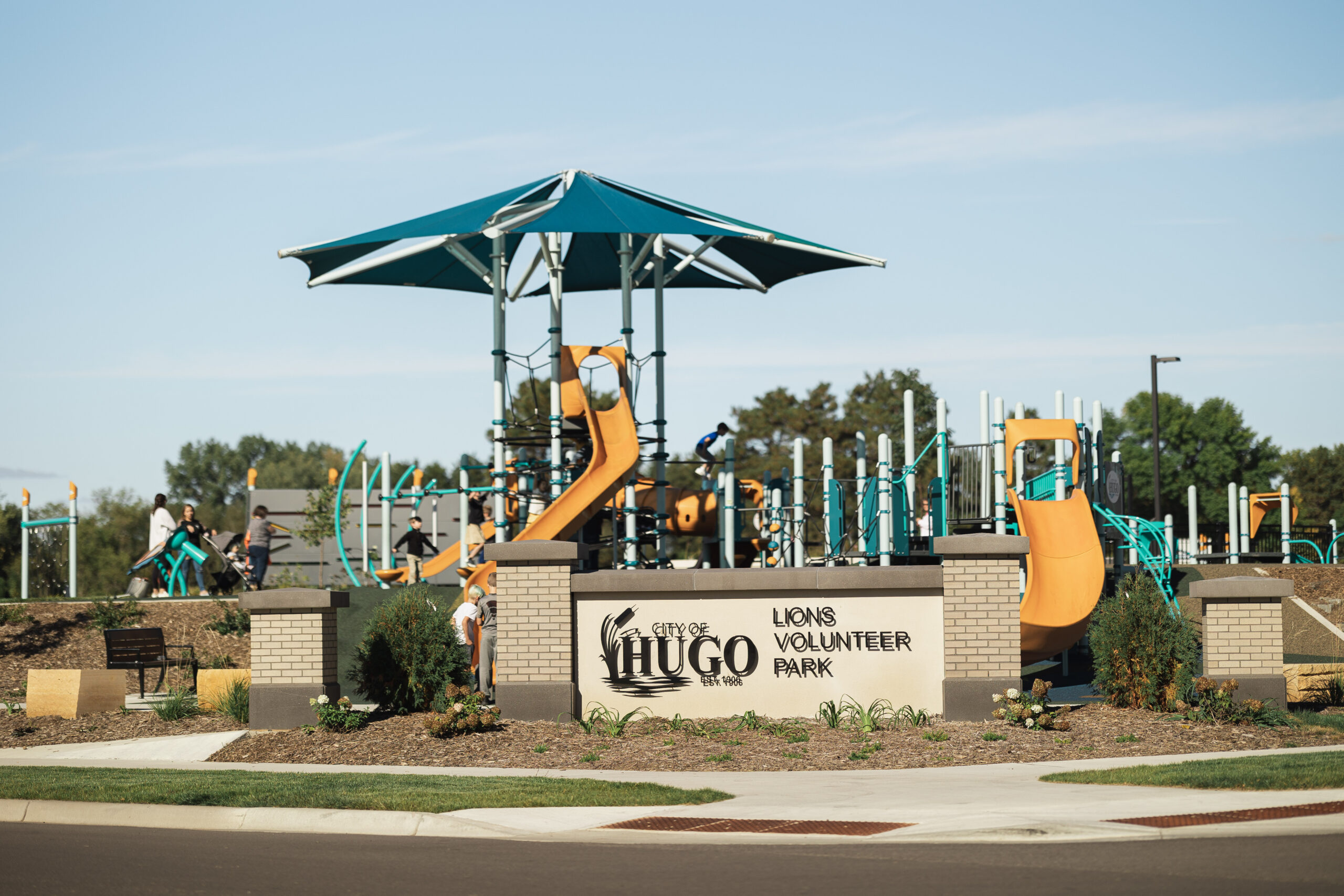
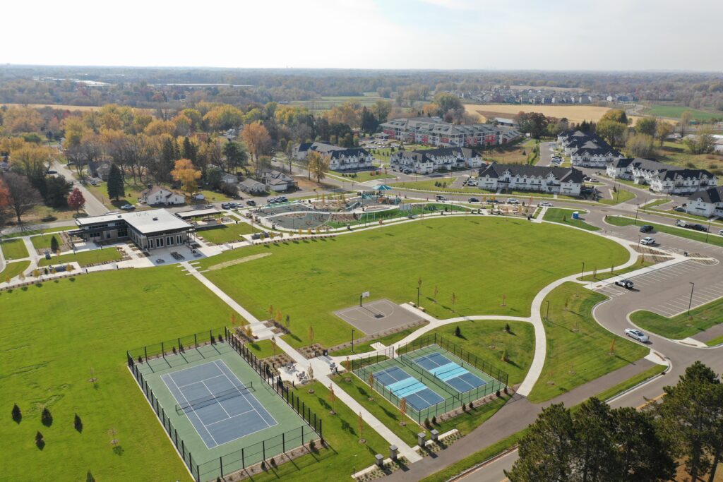
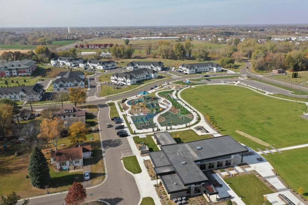
The City of Hugo has been selected as a MRPA Award of Excellence recipient for the Lions Volunteer Park and Downtown Improvement Project. The award will be presented later this summer at a City Council meeting.
WSB’s design team collaborated with the City of Hugo and HCM Architects to engage in a comprehensive planning process aimed at transforming the existing downtown into an expanded civic space. The project was completed in 2022 and features a fully redeveloped park with a wide variety of interactive features meeting a broad range of ages and abilities and includes event space, the Peder Pederson Pavilion, an inclusive playground, and athletic courts. It also includes an abundance of gathering areas surrounded by aesthetic landscaping that is irrigated through a stormwater reuse system. The new and redeveloped streets and trails greatly improve overall access to the park and the Hugo City Hall for both pedestrians and vehicles.