EFFECTIVELY MANAGING GEOHAZARD RISK
Underground pipeline infrastructure is expansive and vulnerable to natural disasters, extreme weather conditions and impairment from human activities. When systems fail, they can trigger catastrophic damage and global headlines. In 2018, extreme weather incidents cost the United States nearly $91 billion. Earthquakes, landslides, tornadoes and hurricanes have a huge impact on our above-ground infrastructure but can also significantly affect our less visible underground infrastructure.
To prepare for the fallout caused by extreme weather events, many private and public organizations are taking a proactive approach to managing their geohazard risk.
PRIVATE REGULATIONS
Private utilities who operate interstate pipelines are held to requirements enforced by the Pipeline and Hazardous Materials Safety Administration (PHMSA). These requirements provide guidance on how to manage operations when faced with extreme weather or natural disasters. Beginning in July 2020, PHMSA’s updated requirements will mandate the consistent monitoring of all pipeline systems throughout the United States. While regulations existed previously, the integrity management systems associated with pipeline infrastructure have been evolving in response to extreme weather.
To comply with the PHMSA’s requirements, many private oil and gas companies are developing and updating integrity management systems, a risk-based approach to improving pipeline safety and operations.
PUBLIC REGULATIONS
Instead of creating integrity management systems, public organizations create resiliency plans. These plans improve public safety, allow for more precise project scoping and cost estimating and provide more accurate forecasting for maintenance budgets. Additionally, resiliency plans help communities plan their budgets proactively.
BUT HOW DO YOU MONITOR UNDERGROUND INFRASTRUCTURE THAT SPANS MILES?
Traditionally, many companies and organizations have resorted to walking the entire pipeline system to measure where risk may occur in the event of a natural disaster or extreme weather event. This process is time-consuming and often not fast enough in response to a crisis or when quick decisions must be made.
Our team of geohazard experts knew there had to be a better way to assess geohazard risk. Working closely with both public and private clients, we developed a predictive tool that allows organizations to monitor their pipeline infrastructure virtually. This GIS-based geohazard model informs risk-based decision-making tools, such as risk matrices, that can be referenced to ensure PHMSA compliance or inform resiliency planning. Using the model, areas that may have been impacted by an extreme weather event can be monitored with the click of a button and action steps can be taken immediately to continue safe operations of the pipeline network.
THE IMPORTANCE OF MANAGING GEOHAZARD RISK
With changing severe weather patterns around the country, proactive management is becoming an increasingly important part of pipeline operations. Since the 1950s, precipitation occurring during heavy downpours has increased by 37% in the Midwest. These events increase the probability of landslides, flooding, and a host of other geohazards that may negatively impact pipeline integrity.
Identifying locations vulnerable to these types of events allow mitigation activities that are less expensive than addressing them after an event has occurred, making geohazard assessments a sound risk and financial management tool.
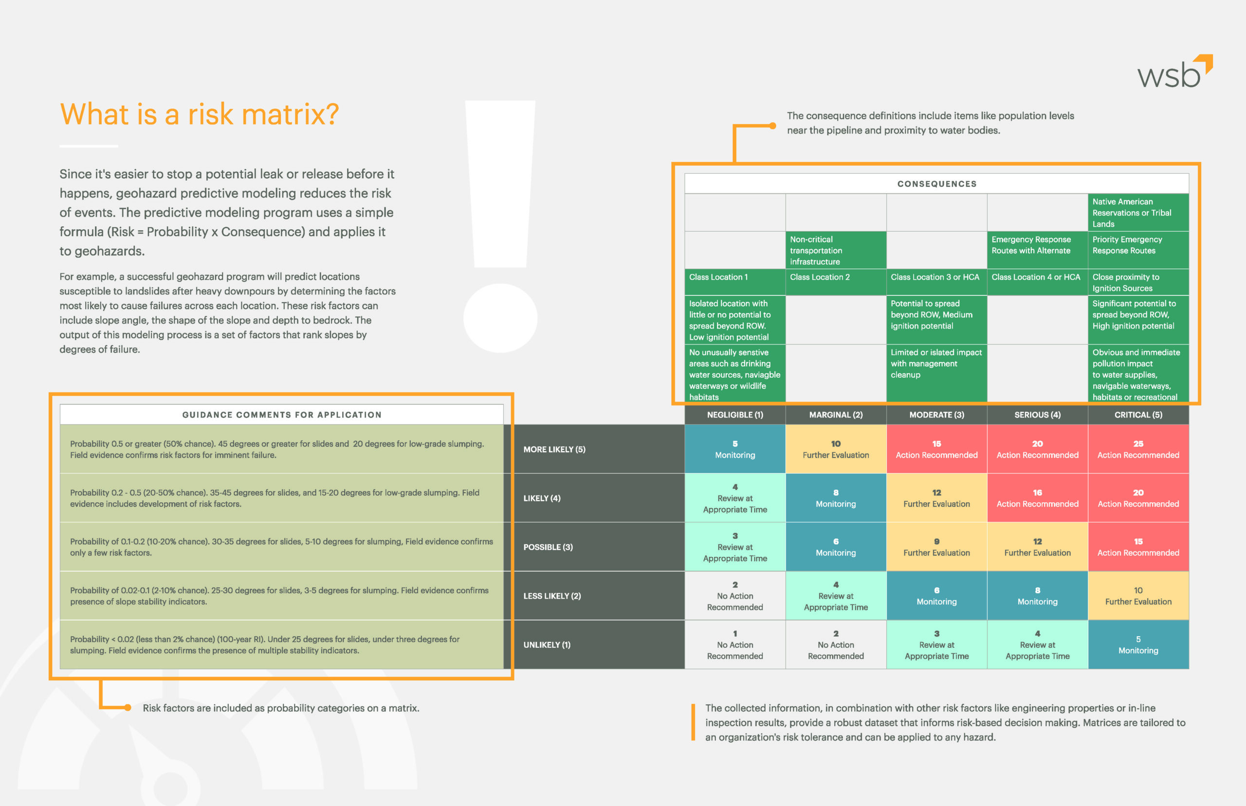
WHAT IS A RISK MATRIX?
Since it’s easier to stop a potential leak or release before it happens, geohazard predictive modeling reduces the risk of events. The predictive modeling program uses a simple formula (Risk = Probability x Consequence) and applies it to geohazards.
For example, a successful geohazard program will predict locations susceptible to landslides after heavy downpours by determining the factors most likely to cause failures across each location. These risk factors can include slope angle, the shape of the slope and depth to bedrock. The output of this modeling process is a set of factors that rank slopes by degrees of failure.