Projects
City of Arden Hills – Lake Valentine Road Traffic & Pedestrian Study
Location:
Arden Hills, MN
Expertise:
Technology, Transportation
Services:
Geospatial, GIS Services, Traffic Engineering
The WSB Traffic team has been pairing the use of drone footage with the collection of traffic data in order to make more comprehensive field observations and gather information on a wider field of view. The team has incorporated drone flights into studies of school circulation, pedestrian safety and the operations for campuses.
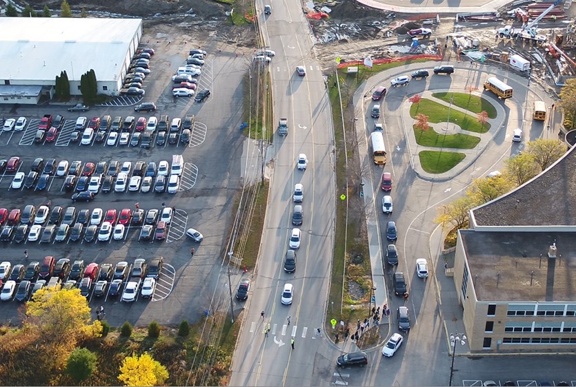
As part of a school expansion project at Mounds View High School in Arden Hills, site modifications resulted in the main parking area for students and staff (700 spaces) being moved across Lake Valentine Road from the school building. Many of the spaces were now closer to the primary entrance, but required crossing a three-lane roadway with an average daily traffic volume (ADT) of 4,300 vehicles. Additionally, there were several conflict and queuing areas present due to the interaction of pedestrians, parent pick-up/drop-off, bus arrival and departure, and through traffic.
The project was focused on improving safety and circulation for all types of travel along Lake Valentine Road and on school property. WSB utilized conventional traffic data collection tools (tube counters, video cameras for vehicle turning movements and field observation) to get a basic understanding of site operations. Drone video was collected during school arrival and dismissal to observe the operations on Lake Valentine Road and across the entire school property. The drone covered three accesses to the school and two accesses to the parking lot on the opposite side of the road.
Using the drone footage, WSB was able to focus on multiple areas for issue mapping, showing operational issues for the entire site, showing how issues in one area can impact the entire system, and compiling statistical information not available from conventional data collection methods.
We used still photos from drone footage to create issues maps, figures showing mitigation alternatives, and additional ways to present information during a work session with the city council, staff and school/schoolboard members.
The figures and video were used to explain issues and alternatives that would have been difficult to convey with surface photographs or the older aerial photos that were available.
The primary advantages of using drone video for large traffic studies include:
- The ability to observe the relationships of how operations in one area affect other accesses and circulation areas
- Observing how queuing and delay can rapidly develop from minor events
- Provide a system-wide vantage point for identifying issues and potential mitigation alternatives
- Provide figures and video for conveying information during public meetings to better communicate with stakeholders